2H. General Information Signs¶
§2H.01 Scope¶
Support
01. General Information signs provide road users with navigational or orientation, geographic, or other information useful for traffic operational purposes. They include such items as State lines, city limits, time zones, stream names, elevations, landmarks, and similar geographic features. Chapter 2M contains recreational and cultural interest area symbol signs that are sometimes used in combination with General Information Signs. Section 1D.09 contains information on unnecessary traffic control devices. Section 2A.20 contains information on the excessive use of signs and sign clutter.
Option
02. A General Information (I3-5 through I4-2) symbol sign (see Figure 2H-1) may be used to provide direction to a transportation (I3 series signs) or other (I4 series signs) facility. The symbol sign may be supplemented by an educational plaque where necessary. The name of the facility may be used, if needed, to distinguish between similar facilities in the same area.
03. The Advance Turn (M5 series) or Directional Arrow (M6 series) auxiliary plaques (see Figure 2H-1) with white arrows on green backgrounds may be used with General Information symbol signs to create a General Information Directional Assembly.
03a. Refer to Section 2E.17 when a General Information symbol is incorporated into the legend of a guide sign.
04. The Recycling Center (I4-2) symbol sign may be used to direct road users to recycling centers.
Guidance
05. The Recycling Center symbol sign should not be used on freeways and expressways.
Option
06. The Passengers Only Ferry Terminal (I3-10) symbol sign may be used with the FERRY (I3-10P) plaque (see Figure 2H-1) mounted below it in a directional assembly to direct road users to passenger-only ferry terminals.
Guidance
07. General Information signs should not be installed within a series of guide signs, or at other equally critical locations, unless there are specific reasons for orienting the road user or identifying control points for activities that are clearly in the public interest. On all such signs, the designs should be simple and dignified, devoid of any tendency toward advertising, such as complex graphics or unnecessary messages, and in general compliance with other guide signing.
Standard
08. Promotional descriptive messages that are not relevant to navigation and orientation, such as “Scenic” or “Historic,” shall not be included in the legends of General Information signs, except as otherwise provided in this Chapter or in cases in which these terms are part of an official name, such as for a Scenic Byway or Historic District.
09. Except for State Welcome signs (see Section 2H.07), Acknowledgment signs (see Section 2H.13), and Alternative Fuels Corridor signs (see Section 2H.14), General Information signs shall have white legends and borders on green rectangular-shaped backgrounds.
§2H.02 Sizes of General Information Signs¶
Standard
01. Except as provided in Section 2A.07, the sizes of General Information signs that have a standardized design shall be as shown in Table 2H-1 and Table 2H-1(CA).
Support
02. Section 2A.07 contains information regarding the applicability of the various columns in Table 2H-1.
Option
03. Signs larger than those shown in Table 2H-1 may be used (see Section 2A.07), except where a maximum allowable size is specified.
§2H.03 Airport Signs¶
Support
00. Refer to FHWA’s List of Known Errors for error in Paragraph 1 heading. Refer to Section 1A.04 for more details.
01. Guide signs for commercial service airports and general aviation airports may be provided from the nearest Interstate, other freeway, or conventional highway intersection directly to the airport, normally not to exceed 15 miles. The Airport (I3-5) symbol sign (see Figure 2H-1) along with a supplemental plaque may be used to indicate the specific name of the airport. An Airport symbol sign, with or without a supplemental name plaque or the word AIRPORT, and an arrow may be used as a trailblazer.
Standard
02. Airport pictographs or other graphical representation of the specific airport shall not be used with or in place of the specific airport name on guide signs.
Guidance
03. If airport guide signs are used, adequate trailblazer signs should be used to provide motorist direction to the airport.
Support
04. Location and placement of all airport guide signs depends upon the availability of longitudinal spacing on highways.
05. Figure 2D-39 shows an example of the guide signing that is typically used for a large commercial airport.
Option
06. The Airport (I3-5) symbol sign may be used for large or small commercial airports and airports which do not accommodate large commercial jet aircraft.
§2H.04 Traffic Signal Speed Sign (I1-1)¶
Option
01. The Traffic Signal Speed (I1-1) sign (see Figure 2H-1) displaying the legend SIGNALS SET FOR XX MPH may be used to indicate a section of street or highway on which the traffic control signals are coordinated into a progressive system timed for a specified speed at all hours during which they are operated in a coordinated mode.
02. If different system progression speeds are set for different times of the day, a changeable message element may be used for the numerals of the Traffic Signal Speed sign. If the system is operated in coordinated mode only during certain times, a blank-out version of the Traffic Signal Speed sign may be used to display the entire message only during those times.
Standard
03. An electronic-display changeable section of the Traffic Signal Speed sign shall be a white legend on a black opaque or green background.
Guidance
If used, the Traffic Signal Speed sign should be mounted as near as practical to each intersection where the timed speed changes, and at intervals of several blocks throughout any section where the timed speed remains constant.
Support
04. The Traffic Signal Speed (I1-1) sign is not used in California because its displayed speed reflects an internal signal timing parameter rather than information intended for motorists.
§2H.05 Jurisdictional Boundary Signs (I2-1)¶
Option
The Jurisdictional Boundary (I2-1) sign may be used to mark the location of the jurisdictional boundary of a State, county, or municipality or the limits of an unincorporated municipal-level community, federally recognized Tribal Nation, or governmental district where legal jurisdiction, road maintenance responsibility, or emergency response obligation changes.
01a. The WHERE WE HONOR VETERANS (G10-4P(CA)) sign may be used below the Jurisdictional Boundary Sign (I2-1) in reference to a county line. Refer to SHC § 1978.
Guidance
02. If used, the Jurisdictional Boundary sign should be located at or as near as practicable to the jurisdictional boundary without interfering with higher-priority traffic control devices. Notices of statutes or local ordinances should
01. be located separately using regulatory signs (see Chapter 2B). If used for an unincorporated community, the community should be one that is readily identifiable on official maps and be consistent with postal mailing addresses.
Standard
04. In accordance with Section 2H.01, the Jurisdictional Boundary sign shall be rectangular in shape and shall have a white legend on a green background. The sign shall display only the name of the State, county, municipality, federally recognized Tribal Nation, or other identifiable community, and an appropriate legend such as ENTERING, STATE LINE, County, or the municipal classification.
05. Names of elected officials or promotional messages, such as notable accomplishments or claims, shall not be displayed on a Jurisdictional Boundary sign or added as a supplemental sign or plaque.
Option
06. A pictograph representing the jurisdiction may be displayed on the Jurisdictional Boundary sign.
Standard
07. If a pictograph is displayed on the Jurisdictional Boundary sign, it shall be the official seal of the jurisdiction and shall comply with the provisions of Section 2A.04. The pictograph shall be placed to the left of the legend. The height of the pictograph shall not exceed 2 times the height of the initial upper-case letter of the principal legend.
Guidance
08. Signs should not be used to identify the boundaries of special-purpose governmental districts, such as school districts, sanitary districts, or improvement districts, as such signs are generally promotional in nature and do not provide navigational or orientation assistance in conjunction with official maps that are available to the general public.
Support
09. Section 2H.07 contains information on State Welcome signs. Unincorporated Community and City Limit (G9-2(CA) and G9-5(CA)) Signs
Standard
10. The Unincorporated Community (G9-2(CA)) and City Limit (G9-5(CA)) signs shall be used to mark the limits of cities and to identify unincorporated towns. Refer to SHC § 101.1.
Guidance
11. The G9-2(CA) signs should be placed on the right, as close as practical to the outer town limits of unincorporated towns, facing traffic entering the named town.
12. The G9-5(CA) sign should be placed on the right, as close as practical to the outer city limits of incorporated cities, facing traffic entering the named city.
Option
13. The population may be obtained from:
- A. Federal census
- B. California Dept. of Finance
- C. County Board of Supervisors
- D. County Planning Commission
14. The elevation shown may be that of the courthouse, post office, railroad station, or benchmark in the central district of the city.
Option
15. On state highways Caltrans may place the state’s 9-1-1 emergency telephone number on county, city, and town limits signs. Refer to § 101.1 of the SHC.
Standard
16. Caltrans, under certain conditions, shall replace any city limit signs. Refer to §§ 101.2 and 101.4 of the SHC.
Guidance
17. If a city or community desires to install a distinctive type city limits or "Welcome" sign on conventional highways at its city limits in place of the standard G9-5(CA) sign, the following criteria should be followed:
Standard
- A. The signs shall be installed by local authorities at no expense to the State, and an approved encroachment permit will be obtained prior to installation. They shall be maintained by the permittee to the satisfaction of the permitter.
- B. Such signs shall be installed in accordance with current Caltrans practices.
- C. Signs shall be of reasonable size and proportional to other guide signs in the area.
- D. Signs shall be positioned so they do not obstruct the view of official traffic control devices.
- E. No moving or flashing displays or advertising of any kind will be permitted.
- F. No sign shall encroach over the highway.
Option
- G. Political jurisdiction logos may be displayed on the city limit signs, but the predominant characteristics of the sign will be white legend on a green rectangular shaped background. Distinctive type city limit signs not conforming to the above may remain in place until normal replacement is required.
§2H.06 Geographical Feature Signs (I2-2)¶
Option
01. The Geographical Feature (I2-2) sign may be used to mark the locations of land features such as river or stream crossings, and summits, that are identifiable on maps or serve as landmarks in providing navigational orientation or reference to the road user.
01a. The Geographical Feature (I2-2) sign may be used to identify bridges or structures across rivers and creeks and provide motorist orientation that is not otherwise included in the primary signing.
Guidance
01b. The I2-2 sign should be used on freeways to identify major river crossings.
02. If used, the Geographical Feature sign should display only the name of the geographical feature. Additional information that is unnecessary for navigational or orientation purposes, such as watershed or tributary names, should not be displayed on the sign. Elevation (G16(CA) and G17(CA)) Signs
Option
03. The Mountain Pass Elevation (G16(CA)) sign may be used at the summit to inform the public of a mountain pass name and elevation.
Guidance
04. The G16(CA) sign should be placed facing traffic in each direction on the right.
Option
05. The Elevation (G17(CA)) sign may be used to inform motorists of changes in elevation. Feet will be shown in multiples of 1,000 feet above sea level, and multiples of 100 feet below sea level.
Guidance
06. The G17(CA) sign should be placed facing traffic in each direction on the right.
§2H.07 State Welcome Signs¶
Support
The design, placement, and function of State Welcome signs that are used to identify State lines differ from Jurisdictional Boundary (I2-1) signs (see Section 2H.05). Because of these differences, it is necessary to distinguish State Welcome signs from State line Jurisdictional Boundary signs.
Option
02. A State Welcome sign may be located at or in the vicinity of the State boundary except as prohibited in Paragraph 4 of this Section.
03. State Welcome signs may display the State seal or the State flag, the officially-adopted State motto or slogan, and the name of the Governor, in addition to the State name. State Welcome signs may use legend and background colors that provide adequate visual contrast rather than the standard sign colors.
Standard
04. State Welcome signs shall be located separate from other signs where they will not interfere with or detract from other traffic control devices.
05. State Welcome signs shall not display changeable or other electronic-display messages (see Chapter 2L). State Welcome signs shall not display messages that emulate promotional advertising of any type. State Welcome signs shall not incorporate Acknowledgment signs or messages (see Section 2H.13), or business identification sign panels or logos (see Section 2J.03) into their legends or assemblies. In accordance with Section 2A.04 of this
01. Manual, telephone numbers, Internet addresses, and e-mail addresses, including domain names and uniform resource locators (URLs), and scanning graphics for the purpose of obtaining information shall not be displayed in the legends of State Welcome signs or on their supports.
Guidance
06. State Welcome signs should be located farther from the edge of the roadway than other traffic control devices.
07. The maximum size of a State Welcome sign should be consistent with the prevailing size of other guide signs based on the roadway type. Welcome to California (G10B(CA)) Sign
Guidance
08. The Welcome to California (G10B(CA)) sign should be used to indicate the California State line. The sign should be placed on the right near the State boundary facing traffic entering the State.
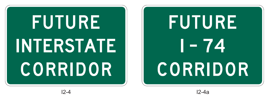
§2H.08 Future Interstate Corridor Signs (I2-4 and I2-4a)¶
Option
01. The Future Interstate Corridor (I2-4 and I2-4a) signs (see Figure 2H-2) may be used sparingly along an existing route that will be reconstructed as an Interstate route or along an existing route adjacent to a corridor through which an Interstate route will be constructed, in accordance with the Policy and Conditions stated in 23 CFR 470, Appendix C.
02. Where the route number has been approved by the FHWA, either the I2-4 or I2-4a sign may be used.
Standard
03. The I2-4a sign shall not be used where the route number has not been approved by the FHWA.
04. Future Interstate Corridor signs shall not be located where they could interfere with or detract from other traffic control devices. If used, Future Interstate Corridor signs shall be installed as independent, post-mounted sign assemblies.
05. Future Interstate Corridor signs shall not imply that an existing route has already been designated and marked as an Interstate route. Signs indicating that an existing route is designated as a future Interstate route or corridor shall not provide directional or distance information. Route Sign assemblies (see Section 2D.29) of any type shall not be used to sign a route as a future Interstate or other route. The Interstate route marker, or likeness thereof, shall not be displayed on the Future Interstate Corridor signs.
Guidance
06. Future Interstate Corridor signs should be limited to strategic locations, such as at the beginning of the designated route or corridor, or beyond interchanges connecting from existing Interstate highways.
§2H.09 Project Information Sign (I2-5)¶
Support
For Construction Project Funding Identification Signs, please refer to section 6I.101(CA).
01. The Project Information (I2-5) sign (see Figure 2H-3) provides limited information to road users about a highway construction project on which work is imminently forthcoming or ongoing.
Standard
02. The Project Information sign legend shall be limited to the following project information:
- A. The roadway name or route number,
- B. A brief description or title of the project,
- C. The completion date expressed in either a month or season (Spring, Summer, Fall, or Winter), and
- D. The agency name.
Option
03. Project Information signs installed more than one week prior to commencement of work may include a start date.
Standard
04. Project Information signs shall not be installed more than one month prior to the commencement of work. When installing Project Information signs prior to the commencement of work, the jurisdiction shall have a policy on when the Project Information signs are to be installed. Project Information signs shall be removed at the conclusion of work on the project, even if the final inspection or project closeout has not yet occurred.
05. The number of Project Information signs shall be limited to one per direction of travel on the roadway on which the project is based. The location of the Project Information sign shall not interfere with the temporary
06. traffic control zone devices. The Project Information sign shall have a white legend on a green background and shall not display Internet addresses, e-mail addresses, or telephone numbers (see Section 2A.04).
§2H.10 Grade-Separated Roadway Identification Signs (I2-3 and I2-3a)¶
Option
01. The Grade-Separated Roadway Identification (I2-3 and I2-3a) signs (see Figure 2H-4) may be used to identify a grade separation of another highway or other transportation facility such as a railway, bikeway, or pathway.
Guidance
02. Except as provided in Paragraph 4 of this Section, when used to identify an overcrossing structure, the I2-3 sign should be mounted above the travel lanes if no vertical clearance signs are present. If vertical clearance signs are present, the I2-3 sign should be mounted above the or shoulder (right or left) of the highway below, or over the median.
03. When used to identify an undercrossing structure, the I2-3 or I2-3a sign should be post-mounted in advance of the structure as near to it as practicable.
Option
04. When used to identify an overcrossing structure, the I2-3 or I2-3a sign may be post-mounted in front of an overcrossing or may be mounted to the abutment of the overcrossing facing approaching traffic.
§2H.11 Reference Location Signs (D10-1 through D10-3) and Intermediate Reference Location Signs (D10-1a through D10-3a)¶
Support
There are two types of reference location signs:
- A. Reference Location (D10-1 through D10-3) signs (see Figure 2H-5) show an integer distance point along a highway, and
- B. Intermediate Reference Location (D10-1a through D10-3a) signs (see Figure 2H-6) show the same information as Reference Location signs, but they also show a tenth-of-a-mile decimal so that they can be installed between integer distance points along a highway.
Standard
02. Except when Enhanced Reference Location signs (see Section 2H.12) are used instead, Reference Location (D10-1 through D10-3) signs shall be placed on all expressway facilities that are located on a route where there is reference location sign continuity and on all freeway facilities to assist road users in estimating their progress, to provide a means for identifying the location of emergency incidents and traffic crashes, and to aid in highway maintenance and servicing.
Option
03. Reference Location (D10-1 through D10-3) signs may be installed along any section of a highway route or ramp to assist road users in estimating their progress, to provide a means for identifying the location of emergency incidents and traffic crashes, and to aid in highway maintenance and servicing. on the highway.
04. To augment the Reference Location sign system, Intermediate Reference Location (D10-1a through D10-3a) signs, which show the tenth of a mile with a decimal point, may be installed at one tenth of a mile, two tenths of a mile, or one-half mile intervals.
Standard
05. When Intermediate Reference Location (D10-1a through D10-3a) signs are used to augment the reference location sign system, the reference location sign at the integer mile point shall display a decimal point and a zero numeral.
06. Reference Location and Intermediate Reference Location signs shall have a minimum mounting height of 4 feet, measured vertically from the bottom of the sign to the elevation of the near edge of the roadway, and shall not be governed by the mounting height requirements prescribed in Section 2A.15.
07. The distance numbering shall be continuous for each route within a State, except where overlaps occur (see Section 2E.22). Where routes overlap, reference location sign continuity shall be established for only one of the routes. If one of the overlapping routes is an Interstate route, that route shall be selected for continuity of distance numbering.
01. The route selected for continuity of distance numbering shall also have continuity in interchange exit numbering (see Section 2E.22).
Guidance
09. On a route without continuity of distance numbering, the first reference location sign beyond the overlap should indicate the total distance traveled on the route (including on the portion that did not have continuity of distance numbering) so that road users will have a means of correlating their travel distance between reference location signs with that shown on their odometer.
Standard
10. For divided highways, the distance measurement shall be made on the northbound and eastbound roadways. The reference location signs for southbound or westbound roadways shall be set at locations directly opposite the reference location signs for the northbound or eastbound roadways.
11. Zero distance shall begin at the south and west State lines, or at the south and west terminus points where routes begin within a State.
12. Except as provided in Paragraph 13 of this Section, reference location signs shall be installed on the right-hand side of the roadway.
Option
13. Where conditions limit or restrict the use of reference location signs on the right-hand side of the roadway, they may be installed in the median. On two-lane conventional roadways, reference location signs may be installed on one side of the roadway only and may be installed back-to-back. Reference location signs may be placed up to 30 feet from the edge of the pavement.
14. If a reference location sign cannot be installed in the correct location, it may be moved in either direction as much as 50 feet.
Guidance
15. If a reference location sign cannot be placed within 50 feet of the correct location, it should be omitted.
Standard
16. In California, reference posts shall be mileage based.
17. The placement and location of reference posts on State highways shall conform to the database maintained by Caltrans’ Division of Traffic Operations for reference posts. This database is different from the TASAS Highway database.
§2H.12 Enhanced Reference Location Signs (D10-4) and Intermediate Enhanced Reference Location Signs (D10-5)¶
Support
01. There are two types of enhanced reference location signs:
- A. Enhanced Reference Location (D10-4) signs (see Figure 2H-7), and
- B. Intermediate Enhanced Reference Location (D10-5) signs (see Figure 2H-7).
Option
02. An Enhanced Reference Location (D10-4) sign, which enhances the reference location sign system by identifying the route, may be placed on freeways or expressways (instead of reference location signs) or on conventional roads.
03. To augment an enhanced reference location sign system, an Intermediate Enhanced Reference Location (D10-5) sign, which shows the tenth of a mile with a decimal point, may be installed along any section of a highway route or ramp at one tenth of a mile, two tenths of a mile, or one-half mile intervals.
Standard
04. When an Intermediate Enhanced Reference Location (D10-5) sign is used to augment the reference location sign system, the Enhanced Reference Location sign at the integer mile point shall display a decimal point and a zero numeral.
05. Except as provided in Paragraph 6 of this Section, if enhanced reference location signs are used, they shall be vertical signs having a green background with a white legend and border, except for the route shield, which shall be the standard color and shape. The top line shall display the cardinal direction for the roadway. The second line shall display the applicable route shield for the roadway. The third line shall identify the mile reference for the location and the bottom line of the Intermediate Enhanced Reference Location sign shall give the tenth of a mile reference for the location preceded by a decimal point.
Support
Refer to FHWA’s List of Known Errors for error in Paragraph 5 text. Refer to Section 1A.04 for more details.
06. The provisions in Section 2H.11 regarding mounting height, distance numbering and measurements, mileage-based requirements, sign continuity, and placement with respect to the right-hand shoulder and/or median for reference location signs also apply to enhanced reference location signs.
§2H.13 Acknowledgment Signs and Plaques (I20 Series)¶
Support
01. Acknowledgment signs and plaques (see Figure 2H-8) are a way of recognizing a company, business, or volunteer group that provides or sponsors a highway-related service. Acknowledgment signs include sponsorship signs for adopta-highway litter removal programs, maintenance of a parkway or interchange, and other highway maintenance or beautification sponsorship programs.
Guidance
02. A State or local highway agency that elects to have a sponsorship acknowledgement program should develop a policy on Acknowledgment signs and plaques. The policy should require that eligible sponsoring organizations comply with State laws prohibiting discrimination based on race, religion, color, age, sex, national origin, and other applicable laws.
Standard
03. The State or local acknowledgment sign policy shall include all of the provisions regarding placement and design of Acknowledgment signs and plaques that are contained in this Section.
04. Because regulatory, warning, and guide signs have a higher priority, Acknowledgment signs shall only be installed where adequate spacing is available between the Acknowledgment sign and other higher priority signs. Acknowledgment signs shall not be installed in a position where they would obscure the road users’ view of other traffic control devices.
05. Acknowledgment signs shall not be installed at any of the following locations:
- A. On the front or back of, adjacent to, or around any other traffic control device, including traffic signs, highway traffic signals, and changeable message signs;
- B. On the front or back of, adjacent to, or around the supports or structures of other traffic control devices, or bridge piers; or
- C. At key decision points where a road user’s attention is more appropriately focused on other traffic control devices, roadway geometry, or traffic conditions, including exit and entrance ramps, merging or weaving areas, lane terminations, intersections, grade crossings, toll plazas, temporary traffic control zones, and areas of limited sight distance.
06. Acknowledgment signs and plaques shall have a white legend and border on a blue background. Acknowledgment signs shall be independent post-mounted roadside installations only and shall not be mounted overhead.
Option
07. An Acknowledgment sign may be used to acknowledge the sponsor of a rest area or welcome center.
Standard
08. Acknowledgment signs for a rest area, when located on the highway mainline, shall be limited to one sign per direction of travel from which the rest area is accessible, shall be located at least 500 feet from other traffic control devices, and shall not display names or representations of specific products or services provided by the sponsor within the rest area. Acknowledgment signs for rest areas shall display the legend REST AREA as the program activity, such as REST AREA SPONSORED BY. In accordance with Paragraph 5 of this Section, the Rest Area and Welcome Center Acknowledgment (I20-4 and I20-4a) signs shall not be combined in the same sign assembly with or substitute for the Rest Area General Service guide signs (see Section 2I.05).
Option
09. An additional Acknowledgment sign may be used within the rest area provided that it is not visible from the highway mainline or ramps to and from the rest area. If a State has officially adopted and is actively promoting a program to encourage the use of safety rest areas through the use of a program name, then that program name may be displayed in smaller lettering below the legend REST AREA on the Rest Area Acknowledgment sign.
Standard
11. Program names or slogans, as described in Paragraph 14 of this Section, shall not be displayed on the Rest Area General Service guide signs or other types of traffic signs.
Guidance
12. The minimum spacing between Acknowledgment signs and any other traffic control signs, except parking regulation signs, should be:
- A. 150 feet on roadways with speed limits of less than 30 mph,
- B. 200 feet on roadways with speed limits of 30 to 45 mph, and
- C. 500 feet on roadways with speed limits greater than 45 mph.
13. If the placement of a newly-installed higher-priority traffic control device, such as a higher-priority sign, a highway traffic signal, or a temporary traffic control device, conflicts with an existing Acknowledgment sign, the Acknowledgment sign should be relocated, covered, or removed.
Option
14. State or local highway agencies may use their own pictograph (see definition in Section 1C.02) and/or a brief jurisdiction-wide program name, such as “Adopt-A-Highway” or “Litter Removal,” as part of any portion of the Acknowledgment sign, provided that the signs comply with the provisions for shape, sign and legend size, color, and lettering style in this Chapter and in Chapter 2A.
Guidance
15. Acknowledgment signs should clearly indicate the type of highway services provided by the sponsor.
Standard
16. In addition to the general provisions for signs described in Chapter 2A and the sign design principles covered in the “Standard Highway Signs” publication (see Section 1A.05), Acknowledgment sign and plaque designs developed by State or local highway agencies shall comply with the following provisions:
- A. Neither the sign or plaque design nor the sponsor acknowledgment name or logo shall contain any contact information, directions, slogans (other than a brief jurisdiction-wide program name, if used), telephone numbers, e-mail or Internet addresses, including domain names and uniform resource locators (URLs), metadata tags (“hash-tags”), or quick-response (QR) codes, bar codes, or similar scanning graphics (see Section 2A.04);
- B. Except for the sponsor acknowledgment logo, all of the lettering shall be in upper-case letters of the Standard Alphabets as provided in the “Standard Highway Signs” publication (see Section 1A.05);
- C. If a logo, instead of a word legend, is used to represent the sponsor, the logo shall be the primary logo that identifies the sponsoring entity. Secondary or alternate logos, slogans, products, mascots, spokespersons, or other items associated with the sponsoring entity’s commercial advertising or marketing shall not be displayed on Acknowledgment signs or plaques;
- D. In order to keep the main focus on the highway-related service and not on the sponsor acknowledgment name or logo, the area reserved for the sponsor acknowledgment name or logo shall not be located at the top of the sign or plaque, shall be a maximum of 8 square feet in area, and shall not exceed ⅓ of the total area of the sign;
- E. The entire sign display area of an Acknowledgment sign assembly shall not exceed 24 square feet;
- F. The sign or plaque shall not contain any messages, lights, symbols, or logos that resemble any official traffic control devices;
- G. The sign or plaque shall not contain any external or internal illumination, light-emitting diodes, luminous tubing, fiber optics, luminescent panels, or other flashing, moving, or animated features;
- H. The sign or plaque shall not distract from official traffic control messages such as regulatory, warning, or guidance messages;
- I. The area of the plaque shall not exceed the lesser of ⅓ the area of the General Service sign below which it is mounted or 24 square feet;
- J. The plaque size shall be based on the standard sizes as specified in Table 2H-1. If the size of the General Service sign is oversized for its application (greater than the size specified for the corresponding roadway
10. application in Table 2H-1), or if the size of the General Service sign increases due to modification of the sign legend, a corresponding increase in the size of the plaque shall not be allowed; and
- K. The sign or plaque shall not display promotional or contact information about the agency’s sponsorship program, including if the sign or plaque does not currently display a sponsor.
Option
17. If a specific outlet of a business with multiple locations in the same area is the sponsoring entity, such as a franchisee, the area reserved for the sponsor acknowledgment name or logo may include the name of the municipality or neighborhood in which the sponsoring entity is located.
18. An Acknowledgment plaque may be mounted below the following General Service signs to acknowledge the sponsor of a corridor-based or region-based highway-related service:
- A. Radio-Weather Information (D12-1) sign (see Section 2I.09);
- B. Radio-Traffic Information (D12-1a) sign (see Section 2I.09);
- C. TRAVEL INFO CALL 511 (D12-5 and D12-5a) signs (see Section 2I.12); and
- D. Roadside Assistance (D12-6) sign (see Section 2I.13).
19. An Acknowledgment plaque shall not be mounted in conjunction with any other sign or traffic control device. An Acknowledgment plaque shall not be used alone or without one of the General Service signs specified in Paragraph 18 of this Section.
20. The general restrictions on the type of content allowed for display on Acknowledgment signs (see Paragraph 16 of this Section) shall apply to the legends of Acknowledgment plaques.
Support
21. The requirements in Section 2H.13 do not apply to State highways.
§2H.14 Alternative Fuels Corridor Sign (D9-19)¶
Option
01. The Alternative Fuels Corridor (D9-19) sign (see Figure 2H-9) may be used to inform motorists of an alternative fuels corridor highway segment that has been designated by the Secretary of Transportation as “Corridor Ready.”
Standard
02. Alternative Fuels Corridor signs shall only be used to designate alternative fuels corridor highway segments that have been designated by the Federal Highway Administration as “Corridor Ready.” The appropriate General Service signs or plaques identifying the alternative fuels available in the corridor shall be included with the Alternative Fuels Corridor sign in a sign assembly. The alternative fuel services for an alternative fuels corridor shall be limited to electric vehicle charging, compressed natural gas, liquid natural gas, liquified petroleum, and hydrogen.
Support
03. The General Service (D9-11a, D9-11b, D9-11d, D9-11e, and D9-11f) symbol signs for use with an Alternative Fuels Corridor sign are shown in Figure 2I-1.
Standard
04. Alternative Fuels Corridor signs shall only be post-mounted on the side of the road and shall not be mounted overhead.
05. State or agency variations of the Alternative Fuels Corridor sign shall not be allowed. Acknowledgments of sponsors shall not be allowed in Alternative Fuels Corridor sign assemblies.
06. Except as provided in Paragraph 7 of this Section, Alternative Fuels Corridor signs shall be limited to one sign at or near the beginning of the alternative fuels corridor in each direction of travel.
Option
07. For long corridors, such as segments connecting control cities or major urban areas, additional signs may be located beyond major intersections or major interchanges following the typical post-interchange sign sequence.
08. The beginning of an alternative fuels corridor may be indicated with a BEGIN (M4-14P) plaque (see Figure 2H-9) with a white legend and border on a blue background mounted above the alternative fuels corridor sign in the sign assembly.
Support
08a. Refer to FHWA’s List of Known Errors for error in Paragraph 8 text. Refer to Section 1A.04 for more details.
Option
09. The end of an alternative fuels corridor may be indicated with an END (M4-6P) plaque (see Figure 2H-9) with a white legend and border on a blue background mounted above the Alternative Fuels Corridor sign in the sign assembly.
Standard
10. The General Service signs shall not be used in the sign assembly indicating the end of a corridor.
11. When the availability of one or more of the alternative fuel facilities discontinues in an alternative fuels corridor, the LAST IN CORRIDOR (W16-19P) plaque (see Figure 2H-9) shall be included on the last General Service directional assembly on the approach to the interchange or intersection.
Option
12. When the availability of one or more of the alternative fuel facilities discontinues in an alternative fuels corridor, an Alternative Fuels Corridor sign with accompanying General Service signs indicating the types of fuels still available in the corridor may be provided beyond the intersection or interchange where the last discontinued fuel facilities were available.
13. When the distance between electric vehicle (EV) charging services in an alternative fuels corridor is greater than 50 miles, the Next EV Charging (D9-17a) sign (see Figure 2H-9) may be located after the EV charging directional assembly, but before the EV charging service exit or turn, to inform road users of the extended distance to the next EV charging service.
Standard
14. The Alternative Fuels Corridor (D9-19) sign shall not be used as a directional sign in a directional assembly, or be combined with other signs, except as provided in this Section.
Option
15. Up to three General Service symbol signs arranged horizontally displaying the alternative fuels available in the designated corridor may be installed below the Alternative Fuels Corridor sign (see Figure 2H-10).
Standard
16. The size of the General Service symbol signs for the alternative fuels available shall not exceed 18 x 18 inches when mounted with the 24 x 24-inch Alternative Fuels Corridor sign and 24 x 24 inches when mounted with the 36 x 36-inch Alternative Fuels Corridor sign.
Guidance
17. When the number of eligible alternative fuels available in the corridor exceeds three, a separate plaque with the two-letter or three-letter designations (D9-19aP or D9-19bP) of each of the fuels available (see Figure 2H-9) should be used in place of the General Service symbol signs.
Standard
18. When the Alternative Fuels Corridor sign is used in a designated corridor on a freeway or expressway, the applicable General Service signs shall be installed on the approach to an interchange in the corridor from which the designated fuel services are available. If the services are not visible from the ramp of a single-exit interchange, the service signing shall be repeated at the intersection of the exit ramp and the crossroad (see Figure 2H-10). Where the alternative fuel facility is not located along the crossroad, additional General Service directional assemblies shall be installed in advance of each subsequent turn to reach the facility (see Figure 2H11).
Support
19. Because regulatory, warning, and guide signs are necessary for safe and efficient movement of traffic, they have a higher priority in placement location over Alternative Fuels Corridor signs.
Standard
20. Alternative Fuels Corridor sign assemblies shall be limited to those locations where adequate spacing is available between the Alternative Fuels Corridor sign and other signs. Alternative Fuels Corridor signs shall not be installed in a location where they might distract driver’s attention from other traffic control devices or the roadway in a complex roadway environment. If the placement of a newly-installed, higher-priority traffic control device conflicts with an existing Alternative Fuels Corridor sign, the Alternative Fuels Corridor sign shall be relocated, covered, or removed.
21. Alternative Fuels Corridor signs shall not be installed on routes other than those officially designated as alternative fuels corridors, even if to provide directional information to such corridors.
§2H.101(CA) Coastal Access (SG28A(CA)) Sign¶
Option
The Coastal Access (SG28A(CA)) sign may be used to identify only those improved coastal access points selected by the Coastal Commission in accordance with the agreement between the California Coastal Commission and Caltrans dated April 30,
§2H.102(CA) The POST OFFICE (SG60A(CA)) Sign¶
Option
The POST OFFICE SG60A(CA) sign may be used in conjunction with the Advance Turn (M5 series) or Directional Arrow (M6 series) auxiliary plaques to indicate the direction to a local post office which is located off the arterial network.
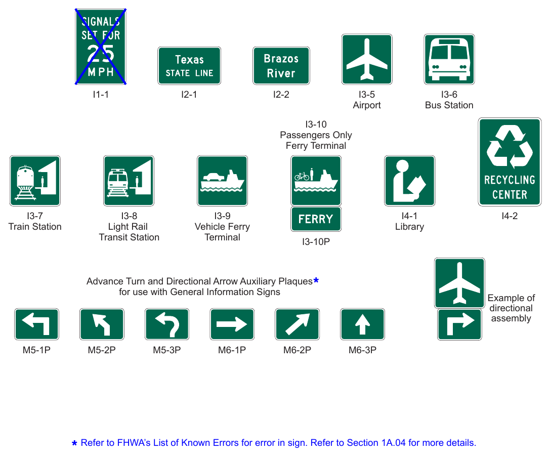
Signs shown: I1-1, I2-1, I2-2, I3-5, I3-6, I3-10, I3-7, I3-8, I3-9, I4-1, I4-2, I3-10P, M5-1P, M5-2P, M5-3P, M6-1P, M6-2P, M6-3P
Refer to FHWA’s List of Known Errors for error in sign. Refer to Section 1A.04 for more details.
.png)
Signs shown: G9-2(CA), G9-5(CA), G10-4P(CA)
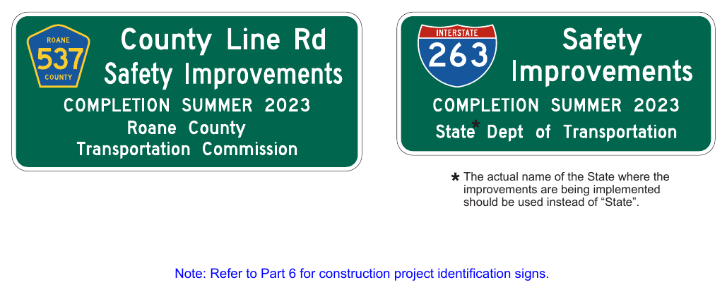
Note: Refer to Part 6 for construction project identification signs.
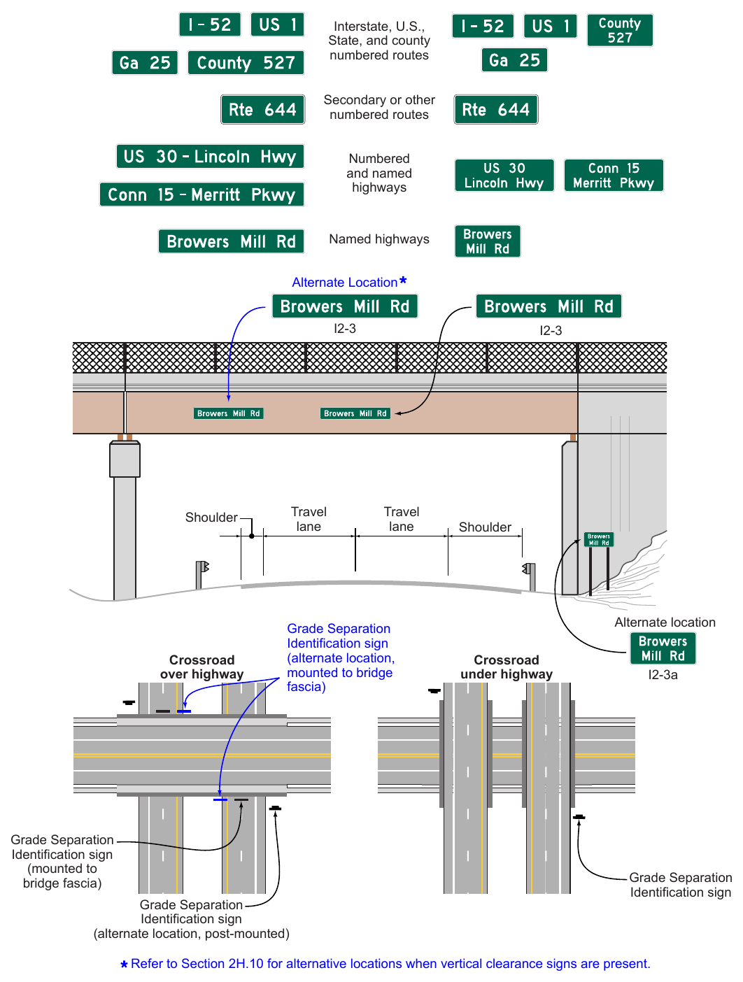
I2-3 (overhead) I2-3a (post-mounted) Interstate, U.S., State, and county numbered routes Secondary or other numbered routes Numbered and named highways Named highways Alternate Location Travel lane Shoulder Crossroad over highway Travel lane Grade Separation Identification sign (alternate location, mounted to bridge fascia) Grade Separation Identification sign (mounted to bridge fascia) Grade Separation Identification sign (alternate location, post-mounted) Shoulder Alternate location Crossroad under highway I2-3a Grade Separation Identification sign Refer to Section 2H.10 for alternative locations when vertical clearance signs are present.
Note: Refer to Figure 2D-4 and 2D-4(CA) for applicable Route Shields to be used on guide signs.
Signs shown: I20-1, I20-2, D12-5, I20-3, I20-4, I20-4a, I20-5P
identification sign panel.
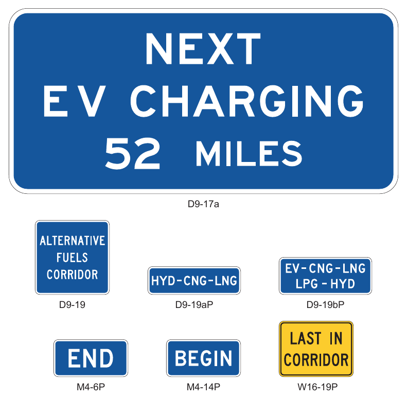
Signs shown: D9-17a, D9-19, D9-19aP, D9-19bP, M4-6P, M4-14P, W16-19P
Signs shown: M4-6P, D9-17a, M4-14P, W16-19P, D9-19, D9-11b, D9-11a, D9-11d
Note: Exit numbering may be used in place of directional arrows on the highway mainline.
Table 2H-1. General Information Sign and Plaque Sizes
| Sign **** | Sign Designation | Section | Conventional Road | Freeway or Expressway |
|---|---|---|---|---|
| Alternative Fuels Corridor | D9-19 | 2H.14 | 24 x 24 | 36 x 36 |
| Alternative Fuels Corridor (1 line) (plaque) | D9-19aP | 2H.14 | 30 x 9 | 42 x 12 |
| Alternative Fuels Corridor (2 lines) (plaque) | D9-19bP | 2H.14 | 30 x 12 | 42 x 18 |
| Reference Location (1 digit) | D10-1 | 2H.11 | 10 x 18 | 12 x 24 |
| Intermediate Reference Location (2 digits) | D10-1a | 2H.11 | 10 x 27 | 12 x 36 |
| Reference Location (2 digits) | D10-2 | 2H.11 | 10 x 27 | 12 x 36 |
| Intermediate Reference Location (3 digits) | D10-2a | 2H.11 | 10 x 36 | 12 x 48 |
| Reference Location (3 digits) | D10-3 | 2H.11 | 10 x 36 | 12 x 48 |
| Intermediate Reference Location (4 digits) | D10-3a | 2H.11 | 10 x 48 | 12 x 60 |
| Enhanced Reference Location | D10-4 | 2H.12 | 12 x 30 18 x 54 (O) | 18 x 54 |
| Intermediate Enhanced Reference Location | D10-5 | 2H.12 | 12 x 36 | 18 x 60 |
| 18 x 60 (O) | ||||
| Traffic Signal Speed | I1-1 | 2H.04 | 24 x 36 | — |
| Jurisdictional Boundary | I2-1 | 2H.05 | Varies x 18** | Varies x 36** |
| Varies x 24 (O) | Varies x 42 (O) | |||
| Geographical Feature | I2-2 | 2H.06 | Varies x 18** Varies x 24 (O) | Varies x 36** |
| Grade Separation Identification | I2-3 | 2H.10 | — | Varies x 18 |
| Grade Separation Identification (2 lines) | I2-3a | 2H.10 | — | Varies x 24 |
| Future Interstate Corridor | I2-4 | 2H.08 | 54 x 36 | 72 x 48 |
| Future I-XX Corridor | I2-4a | 2H.08 | 48 x 36 | 66 x 48 |
| Project Information | I2-5 | 2H.09 | 96 x 48 | 156 x 72 |
| Airport | I3-5 | 2H.01 | 24 x 24 | 30 x 30 |
| Bus Station | I3-6 | 2H.01 | 24 x 24 | 30 x 30 |
| Train Station | I3-7 | 2H.01 | 24 x 24 | 30 x 30 |
| Light Rail Transit Station | I3-8 | 2H.01 | 24 x 24 | — |
| Vehicle Ferry Terminal | I3-9 | 2H.01 | 24 x 24 | 30 x 30 |
| Passenger Only Ferry Terminal | I3-10 | 2H.01 | 24 x 24 | 30 x 30 |
| Ferry (plaque) | I3-10P | 2H.01 | 24 x 12 | 30 x 18 |
| Library | I4-1 | 2H.01 | 24 x 24 | — |
| Recycling Center | I4-2 | 2H.01 | 30 x 36 | — |
| Acknowledgment | I20-1 | 2H.13 | 36 x 30* | 72 x 48* |
| Acknowledgment | I20-2 | 2H.13 | 36 x 30* | 72 x 48* |
| Acknowledgment | I20-3 | 2H.13 | 42 x 24* | 96 x 36* |
| Acknowledgment - Rest Area | I20-4 | 2H.13 | 56 x 36* | 72 x 48* |
| Acknowledgment - Welcome Center | I20-4a | 2H.13 | 56 x 36* | 72 x 48* |
| Acknowledgment (plaque) | I20-5P | 2H.13 | Varies x Varies*** | Varies x Varies*** |
| Last In Corridor (plaque) | W16-19P | 2H.14 | 24 x 18 | 24 x 18 |
* The size shown is the maximum size for the corresponding roadway classification. The size of the sign and acknowledgment logo should be appropriately reduced where shorter legends are used.
** The size shown is for the typical sign illustrated in the figure. The size should be determined based on the number of lines of legend on the sign.
*** Limitations on the size of Acknowledgment plaques are provided in Section 2H.13.
**** Refer to FHWA’s List of Known Errors for error in table. Refer to Section 1A.04 for more details.
Notes: 1. Larger signs may be used when appropriate, except for the I20 series signs and plaque 2. (O) denotes Oversized 3. Dimensions are in inches shown as width x height
acknowledgment logo should be appropriately reduced where shorter legends are used. lines of legend on the sign. Notes: 1. Larger signs may be used when appropriate, except for the I20 series signs and plaque
- 2. (O) denotes Oversized
- 3. Dimensions are in inches shown as width x height
Table 2H-1(CA). California General Information Sign and Plaque Sizes
| Sign or Plaque | Sign Designation | Section | Conventional Road | Freeway or Expressway | ||||||||||
|---|---|---|---|---|---|---|---|---|---|---|---|---|---|---|
| Unincorporated Community | G9-2(CA) | 2H.05 | VAR x 18 | VAR x 30 | ||||||||||
| City Limit | G9-5(CA) | 2H.05 | VAR x 24 | VAR x 42 | ||||||||||
| Welcome to California | G10B(CA) | 2H.07 | 60 x 36 | 132 x 84 | ||||||||||
| WHERE WE HONOR VETERANS (plaque) | G10-4P(CA) | 2H.05 | 60 x 9 | 90 x 12 | ||||||||||
| Mountain Pass Elevation | G16(CA) | 2H.06 | VAR x 18 | VAR x 36 | ||||||||||
| Elevation | G17(CA) | 2H.06 | 36 x 18 | 72 x 36 | ||||||||||
| Coastal Access | SG28A(CA) | 2H.101(CA) | 30 x 24 | 48 x 36 | ||||||||||
| POST OFFICE | SG60A(CA) | 2H.102(CA) | 36 x 24 | — | ||||||||||