Chapter 3B. Pavement and Curb Markings¶
§3B.01 Yellow Center Line Pavement Markings¶
Standard
01. Center line pavement markings, when used, shall be the pavement markings used to delineate the separation of traffic lanes that have opposite directions of travel on a roadway and shall be yellow.
Option
02. Center line pavement markings may be placed at a location that is not the geometric center of the roadway.
03. On roadways without continuous center line pavement markings, short sections may be marked with center line pavement markings to control the position of traffic at specific locations, such as around curves, over hills, on approaches to grade crossings, at grade crossings, and at bridges.
Standard
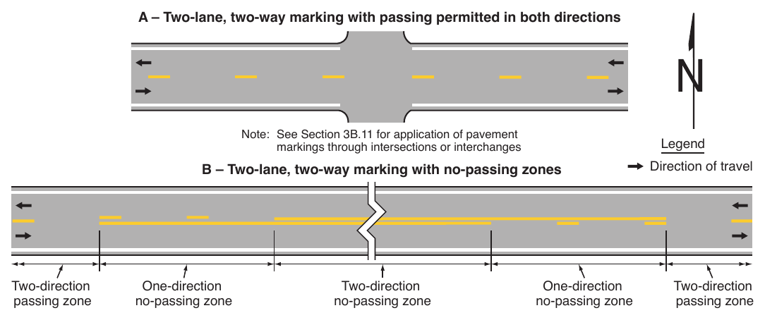
04. The center line markings on two-lane, two-way roadways shall be one of the following as shown in Figure 3B-1:
- A. Two-direction passing zone markings consisting of a normal width broken yellow line where crossing the center line markings for passing with care is permitted for traffic traveling in either direction;
- B. One-direction no-passing zone markings consisting of a double yellow line, one of which is a normal width broken yellow line and the other is a normal width solid yellow line, where crossing the center line markings for passing with care is permitted for the traffic traveling adjacent to the broken line, but is prohibited for traffic traveling adjacent to the solid line; or
- C. Two-direction no-passing zone markings consisting of two normal width solid yellow lines where crossing the center line markings for passing is prohibited for traffic traveling in either direction.
05. A single solid yellow line shall not be used as a center line marking on a two-way roadway.
06. Except where a reversible lane (see Section 3B.04) or a two-way left-turn lane (see Section 3B.05) is present, the center line markings on undivided two-way roadways with four or more lanes for moving motor vehicle traffic always available shall be the two-direction no-passing zone markings consisting of normal width double solid yellow lines as shown in Figure 3B-2.
Support
07. Section 3B.11 contains information for application of pavement markings through intersections or interchanges.
Guidance
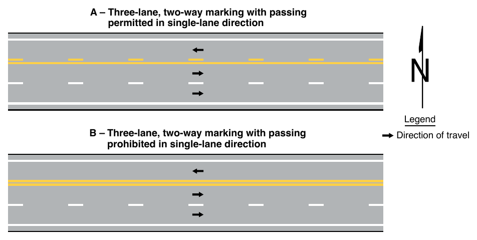
08. On two-way roadways with three through lanes for moving motor vehicle traffic, two lanes should be designated for traffic in one direction by using one-direction or two-direction no-passing zone markings as shown in Figure 3B-3.
Option
09. A curved transition may be used where a center line changes direction.
Support
10. An example of a location where a curved transition can have value is a turn lane.
§3B.02 Warrants for Yellow Center Lines¶
Standard
01. Center line markings shall be placed on all paved undivided two-way urban arterials and collectors that have a traveled way of 20 feet or more in width and an ADT of 6,000 vehicles per day or greater. Center line markings shall also be placed on all paved undivided two-way streets or highways that have three or more lanes for moving motor vehicle traffic.
Guidance
02. Center line markings should be placed on paved urban arterials and collectors that have a traveled way of 20 feet or more in width and an ADT of 4,000 vehicles per day or greater. Center line markings should also be placed on all rural arterials and collectors that have a traveled way of 18 feet or more in width and an ADT of 3,000 vehicles per day or greater. Center line markings should also be placed on other traveled ways where an engineering study indicates such a need.
03. Engineering judgment should be used in determining whether to place center line markings on traveled ways that are less than 16 feet wide because of the potential for traffic encroaching on the pavement edges, traffic being affected by parked vehicles, and traffic encroaching into the opposing traffic lane.
Option
04. Center line markings may be placed on other paved two-way traveled ways that are 16 feet or more in width.
05. If a traffic count is not available, the ADTs described in this Section may be estimates that are based on engineering judgment.
§3B.03 No-Passing Zone Pavement Markings¶
Standard
01. No-passing zones shall be marked by either the one-direction no-passing zone pavement markings or the two-direction no-passing zone pavement markings described in Section 3B.01 and shown in Figures 3B-1 and 3B-3.
02. No-passing zone markings shall be used on:
- A. Two-way roadways at lane-reduction transitions (see Section 3B.12),
- B. Approaches to obstructions that must be passed on the right (see Section 3B.13),
- C. Approaches to grade crossings (see Section 8C.02), and
- D. Approaches to crosswalks.
03. On two-way, two-lane or three-lane roadways where center line markings are installed, no-passing zones shall be established at vertical and horizontal curves and other locations where an engineering study indicates that passing must be prohibited because of inadequate sight distances or other special conditions.
04. On roadways with center line markings, no-passing zone markings shall be used at horizontal or vertical curves where the passing sight distance is less than the minimum shown in Table 3B-1 for the 85th-percentile speed or the speed limit.
Table 3B-1. Minimum Passing Sight Distances for No-Passing Zone Markings
| 85th-Percentile or Speed Limit | Minimum Passing Sight Distance |
|---|---|
| 25 mph | 450 feet |
| 30 mph | 500 feet |
| 35 mph | 550 feet |
| 40 mph | 600 feet |
| 45 mph | 700 feet |
| 50 mph | 800 feet |
| 55 mph | 900 feet |
| 60 mph | 1,000 feet |
| 65 mph | 1,100 feet |
| 70 mph | 1,200 feet |
Support
05. The passing sight distance on a vertical curve is the distance at which an object 3.5 feet above the pavement surface can be seen from a point 3.5 feet above the pavement (see Figure 3B-4). Similarly, the passing sight distance on a horizontal curve is the distance measured along the center line (or right-hand lane line of a three-lane roadway) between two points 3.5 feet above the pavement on a line tangent to the embankment or other obstruction that cuts off the view on the inside of the curve (see Figure 3B-4).
06. The upstream end of a no-passing zone at point “a” in Figure 3B-4 is that point where the sight distance first becomes less than that specified in Table 3B-1. The downstream end of the no-passing zone at point “b” in Figure 3B-4 is that point at which the sight distance again becomes greater than the minimum specified.
Guidance
07. Where the distance between successive no-passing zones is less than 400 feet, no-passing zone markings should connect the zones.
Support
08. No-passing zone signs (see Sections 2B.36, 2B.37, and 2C.53) are sometimes used to emphasize the existence and extent of a no-passing zone.
Standard
09. On three-lane roadways where the direction of travel in the center lane transitions from one direction to the other, a no-passing buffer zone, consisting of a flush median island (see Section 3J.03) at least 50 feet in length, shall be provided in the center lane as shown in Figure 3B-5. A lane-reduction transition (see Section 3B.12) shall be provided approaching each end of the buffer zone.
§3B.04 Yellow Pavement Markings for Reversible Lanes¶
Standard
01. If reversible lanes are used, the lane line pavement markings on each side of reversible lanes shall consist of a normal width broken double yellow line to delineate the edge of a lane in which the direction of travel is reversed from time to time, such that each of these markings serve as the center line markings of the roadway during some period (see Figure 3B-6).
02. Signs (see Section 2B.34), lane-use control signals (see Chapter 4T), or both shall be used to supplement reversible lane pavement markings.
Support
03. Section 3E.02 contains additional applications of pavement markings for counter-flow preferential lanes that also operate as reversible lanes.
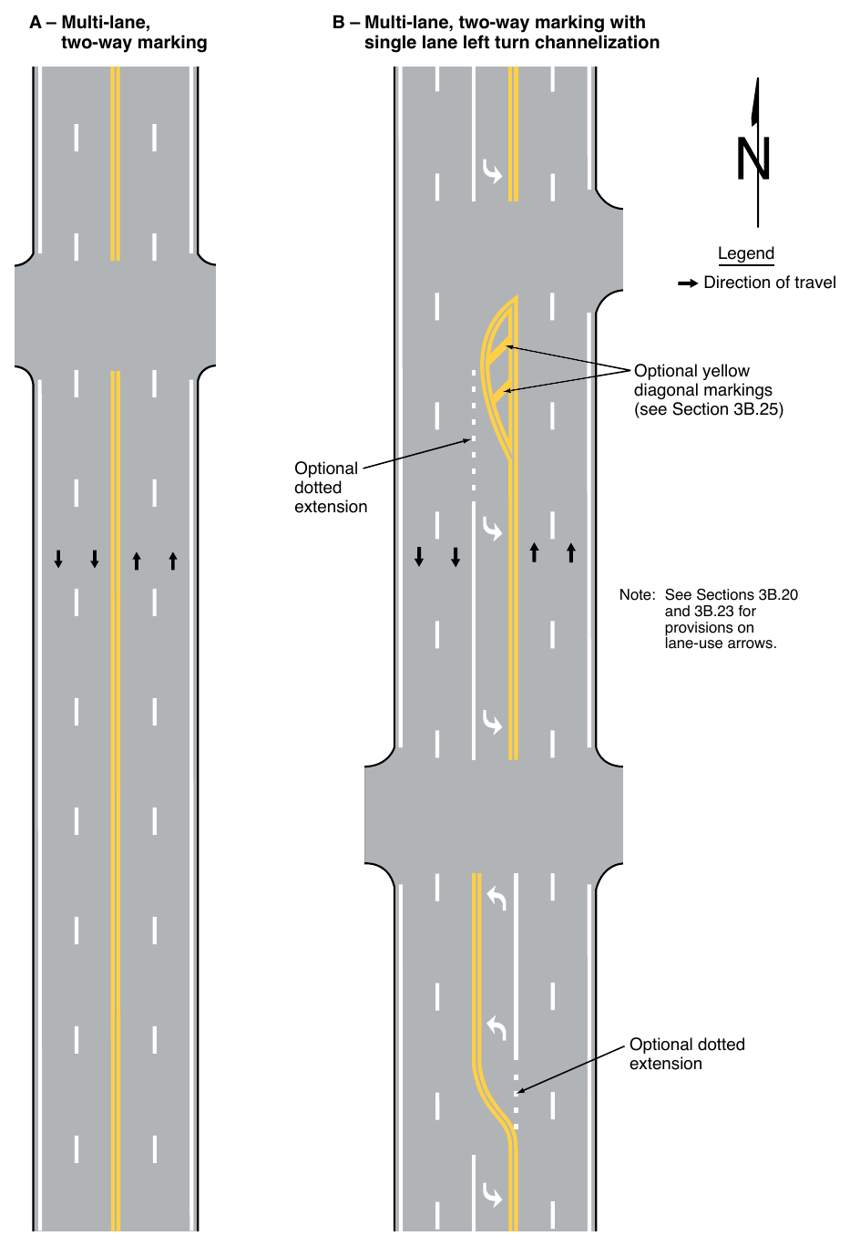
§3B.05 Pavement Markings for Two-Way Left-Turn Lanes¶
Standard
01. If a two-way left-turn lane that is never operated as a reversible lane is used, the lane line pavement markings on each side of the two-way left-turn lane shall consist of a normal width broken yellow line and a normal width solid yellow line to delineate the edges of a lane that can be used by traffic in either direction as part of a left-turn maneuver. These markings shall be placed with the broken line toward the two-way left-turn lane and the solid line toward the adjacent traffic lane as shown in Figure 3B-7.
Guidance
02. White two-way left-turn lane-use arrows should be used at or just downstream from the beginning of a two-way left-turn lane.
- 1. See Section 3B.03 for determining the minimum length of the buffer zone
- 2. See Section 3B.12 for lane-reduction transition markings and determination of taper length L
- 3. See Section 3J.03 for the design of the flush median island Two-direction nopassing marking Zone of limited sight distance, Car “Y” Car “Y” Buffer zone Car “X” Zone of limited sight distance, Car “X” Optional yellow diagonal markings Two-direction nopassing marking (see Note 2) Optional dotted lane line extension
Option
03. Additional two-way left-turn lane-use arrow markings may be used at other locations along a two-way left-turn lane where engineering judgment determines that such additional markings are needed to emphasize the proper use of the lane.
Standard
04. A single-direction lane-use arrow shall not be used in a lane bordered on both sides by yellow two-way left-turn lane longitudinal markings.
Guidance
05. Signs should be used in conjunction with the two-way left-turn markings (see Section 2B.32).
06. Two-way left-turn lane markings should not extend to intersections (see definition in Section 1C.02).
Option
07. Two-way left-turn lanes may be transitioned to mandatory left-turn lanes as shown in Figure 3B-7 or painted median islands where they approach an intersection.
Support
08. Section 8A.06 contains guidance information for discontinuing a two-way left-turn lane in the immediate vicinity of a highway-rail or highway-LRT grade crossing.
§3B.06 White Lane Line Pavement Markings¶
Standard
01. When used, lane line pavement markings delineating the separation of traffic lanes that have the same direction of travel shall be white.
02. Lane line markings shall be used on all freeways and Interstate highways.
Guidance
03. Lane line markings should be used:
- A. On all roadways that are intended to operate with two or more adjacent traffic lanes in the same direction of travel, except as otherwise required for reversible lanes.
- B. At congested locations where the roadway will accommodate more traffic lanes with lane line markings than without the markings.
Support
04. Examples of lane line markings are shown in Figures 3B-2, 3B-3, and 3B-7 through 3B-13.
Standard
05. Except as provided in Paragraph 1 of Section 3B.07, where crossing the lane line markings with care is not discouraged or prohibited, the lane line markings shall consist of a normal width broken white line.
06. Where crossing the lane line markings is discouraged, the lane line markings shall consist of a normal width solid white line.
Guidance
07. A solid white lane line marking should be used on approaches to:
- A. Intersections to separate a through lane from a mandatory turn lane.
- B. Intersections to separate contiguous mandatory turn lanes from each other.
- C. Toll collection points to separate toll lanes, payment methods, channelized movements, or obstructions.
Option
08. Solid white lane line markings may be used:
- A. On approaches to intersections to separate contiguous through lanes.
- B. To separate through traffic lanes from auxiliary lanes, such as an added uphill truck lane.
- C. On approaches to crosswalks across multi-lane roadways.
09. Wide solid lane line markings may be used for greater emphasis.
10. A curved transition may be used where a lane line changes direction.
Support
11. Examples of locations where a curved transition can have value include freeway exit and entrance ramps.
Standard
12. Where crossing the lane line markings is prohibited, the lane line markings shall consist of a double solid white line (see Figure 3B-8).
§3B.07 White Lane Line Markings for Non-Continuing Lanes¶
Standard
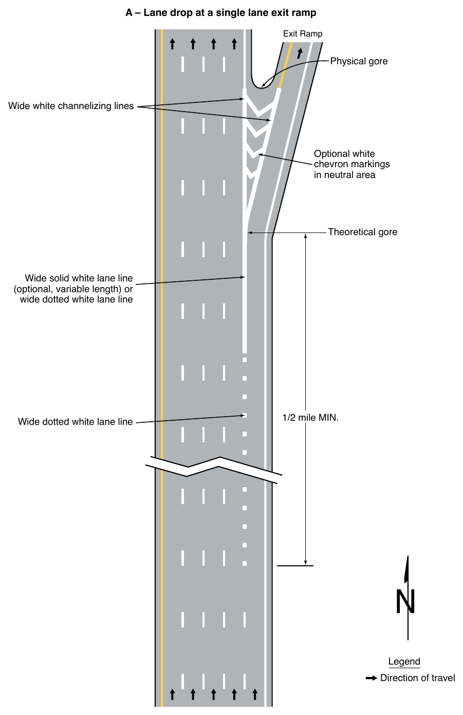
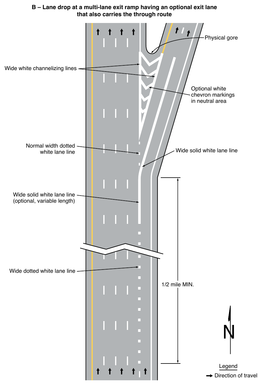
01. A normal width dotted white line marking shall be used as the lane line to separate a through lane that continues beyond the interchange or intersection from an adjacent deceleration or acceleration lane.
02. For exit ramps with a parallel deceleration lane, a normal width dotted white lane line extension shall be installed from the upstream end of the taper to the theoretical gore or to the upstream end of a solid white lane line, if used, that extends upstream from the theoretical gore as shown in Drawings A and C in Figure 3B-9.
03. For an exit ramp with a tapered deceleration lane, a normal width dotted white line extension shall be installed from the theoretical gore through the taper area such that it meets the edge line at the upstream end of the taper as shown in Drawing B in Figure 3B-9.
04. For entrance ramps with a parallel acceleration lane, a normal width dotted white lane line shall be installed from the theoretical gore or from the downstream end of a solid white lane line, if used, that extends downstream from the theoretical gore, to a point at least one-half the distance from the theoretical gore to the downstream end of the acceleration taper, as shown in Drawing A in Figure 3B-10.
Option
05. For entrance ramps with a parallel acceleration lane, a normal width dotted white line extension may be installed from the downstream end of the dotted white lane line to the downstream end of the acceleration taper, as shown in Drawing A in Figure 3B-10.
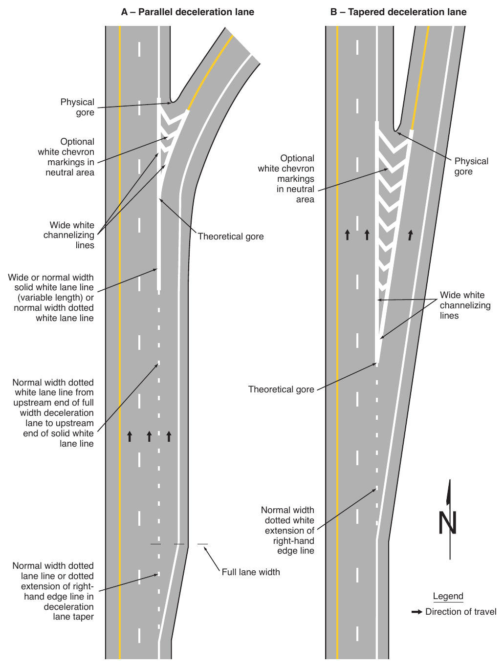
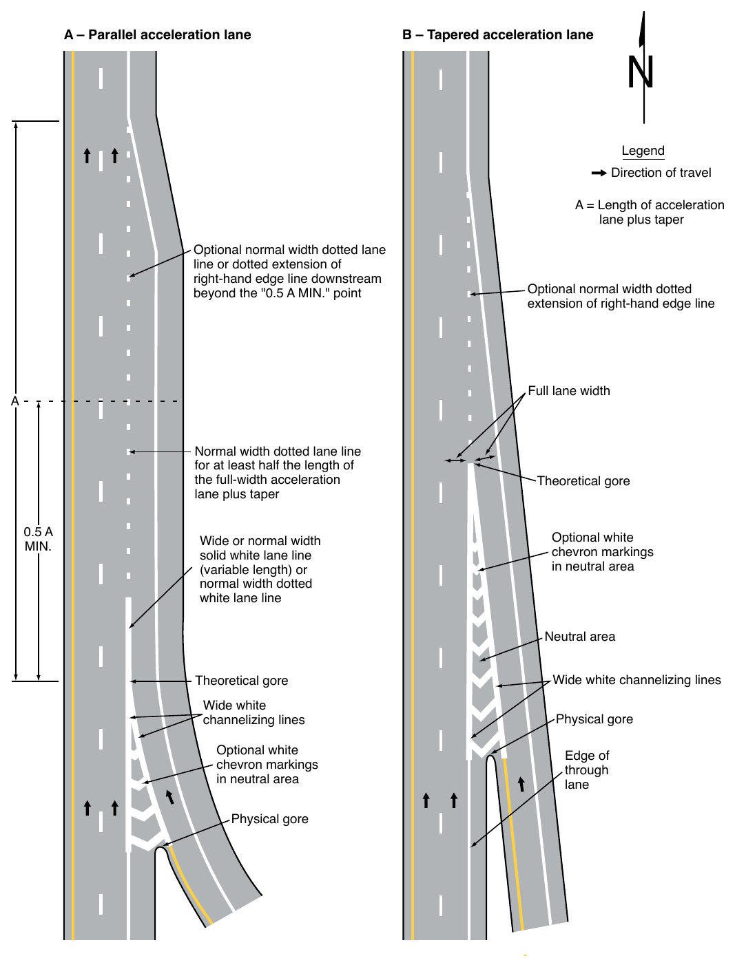
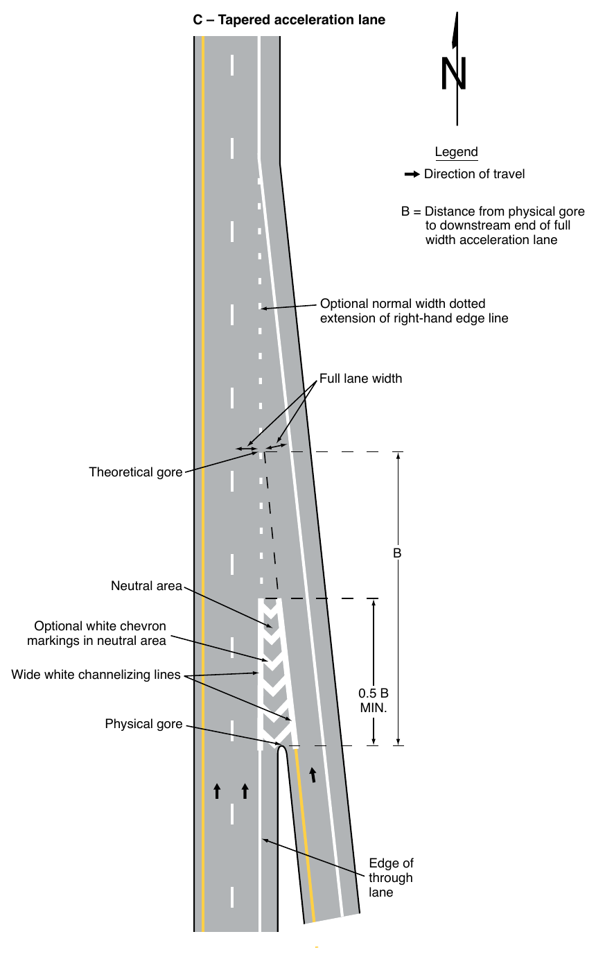
06. for Entrance Ramp Markings (Sheet 2 of 2) C – Tapered acceleration lane Legend Direction of travel B = Distance from physical gore to downstream end of full width acceleration lane Optional normal width dotted extension of right-hand edge line Full lane width Theoretical gore Neutral area Optional white chevron markings in neutral area Wide white channelizing lines Physical gore Edge of through lane For entrance ramps with a tapered acceleration lane, a normal width dotted white line extension may be installed from the downstream end of the channelizing line adjacent to the through lane to the downstream end of the acceleration taper, as shown in Drawings B and C in Figure 3B-10.
Standard
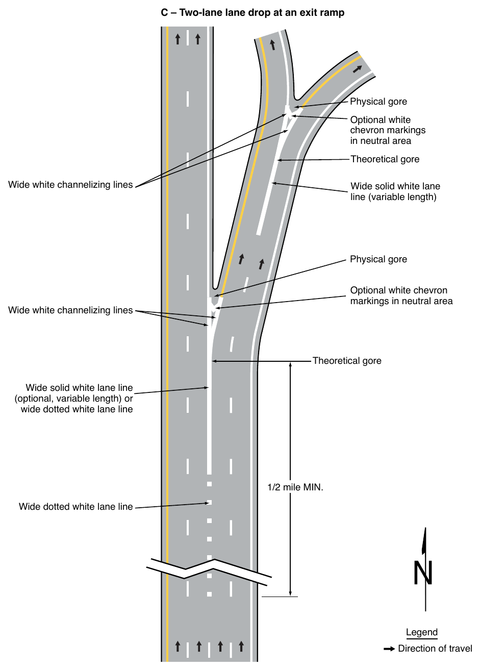
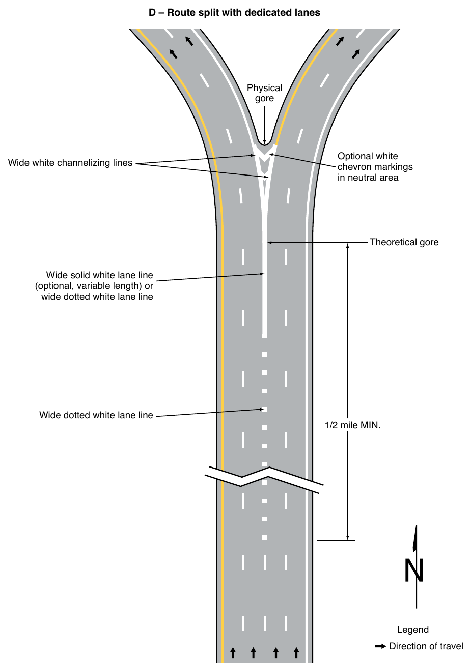
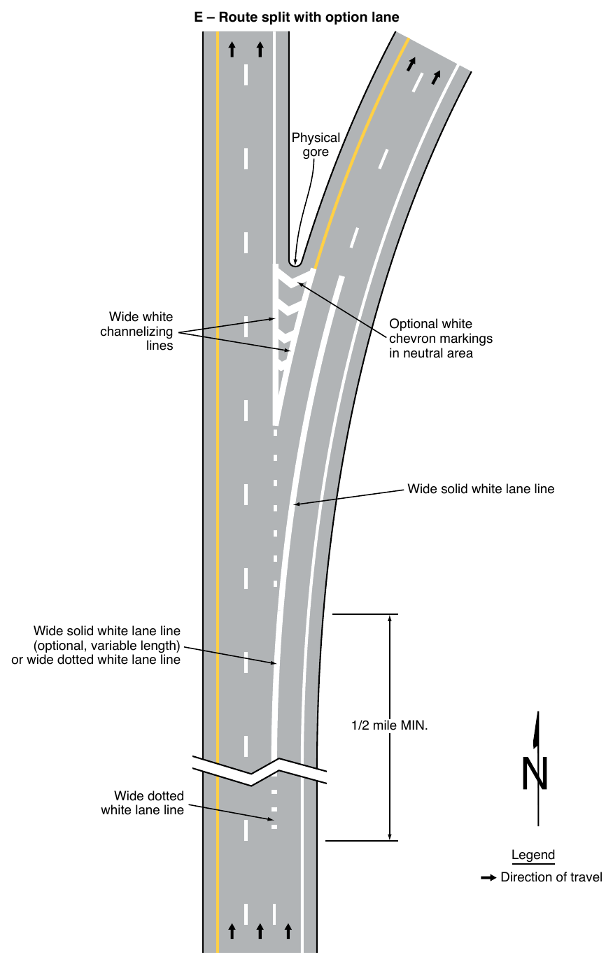
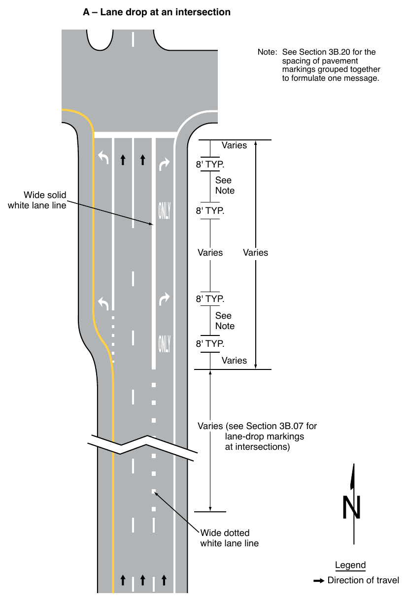
07. A wide dotted white lane line shall be used:
- A. As a lane drop marking in advance of lane drops at exit ramps to distinguish a lane drop from a normal exit ramp (see Drawings A, B, and C in Figure 3B-11),
- B. In advance of freeway route splits with dedicated lanes (see Drawing D in Figure 3B-11),
- C. In advance of freeway route splits with an option lane (see Drawing E in Figure 3B-11),
- D. To separate a through lane that continues beyond an interchange from an adjacent continuous auxiliary lane between an entrance ramp and an exit ramp (see Drawing F in Figure 3B-11),
- E. As a lane drop marking in advance of lane drops at intersections to distinguish a lane drop from an intersection through lane (see Drawing A in Figure 3B-12), and
- F. To separate a through lane that continues beyond an intersection from an adjacent auxiliary lane between two intersections (see Drawing B in Figure 3B-12).
Guidance
08. Lane drop markings used in advance of lane drops at freeway and expressway exit ramps should begin at least ½ mile in advance of the theoretical gore.
09. On the approach to a multi-lane exit ramp having an optional exit lane that also carries through traffic, lane line markings should be used as illustrated in Drawing B in Figure 3B-11.
10. Lane drop markings used in advance of lane drops at intersections should begin a distance in advance of the intersection that is determined by engineering judgment as suitable to enable drivers who do not desire to make the mandatory turn to move out of the lane being dropped prior to reaching the queue of vehicles that are waiting to make the turn. The lane drop markings should begin no closer to the intersection than the most upstream regulatory or warning sign associated with the lane drop.
11. The dotted white lane lines that are used for lane drop markings and that are used as a lane line separating through lanes from auxiliary lanes should consist of line segments that are 3 feet in length separated by 9-foot gaps.
Support
12. Sections 3B.21 and 3B.23 contain information regarding other markings that are associated with lane drops, such as ONLY word pavement markings and lane-use arrows.
13. Section 3B.12 contains information about the lane line markings that are to be used for transition areas where the number of through lanes is reduced at a location that is not at an interchange or intersection.
Option
14. In the case of a lane drop at an exit ramp or intersection, a solid white line may replace a portion, but not all of the length, of the wide dotted white lane line.
15. A curved transition may be used where a dotted extension lane line changes direction.
Support
16. Examples of locations where a curved transition can have value include freeway exit and entrance ramps.
§3B.08 Channelizing Lines¶
Support
01. Channelizing lines are used to form neutral areas where traffic traveling in the same general direction is permitted on both sides including entrance and exit ramps, access and egress points to and from managed lanes, toll-plaza bypasses, and left-turn lanes separated from through lanes. Channelizing lines are also sometimes used to alter travel paths for speed management or other purposes.
02. Chapter 3J contains information for the application of channelizing lines used in conjunction with islands.
Standard
03. Except as provided in Section 3E.04 and Paragraph 6 of Section 3J.05, a channelizing line shall be a solid wide or double solid white line.
Support
04. Examples of channelizing line applications are shown in Figures 3B-9, 3B-10, 3B-11, Drawing C in Figure 3B-15, Figures 3J-1 through 3J-5, and Drawing B in Figure 3J-6.
Standard
05. For all exit ramps and for entrance ramps with parallel acceleration lanes, channelizing lines shall be placed on both sides of the neutral area (see Figures 3B-9 and 3B-11 and Drawing A in Figure 3B-10).
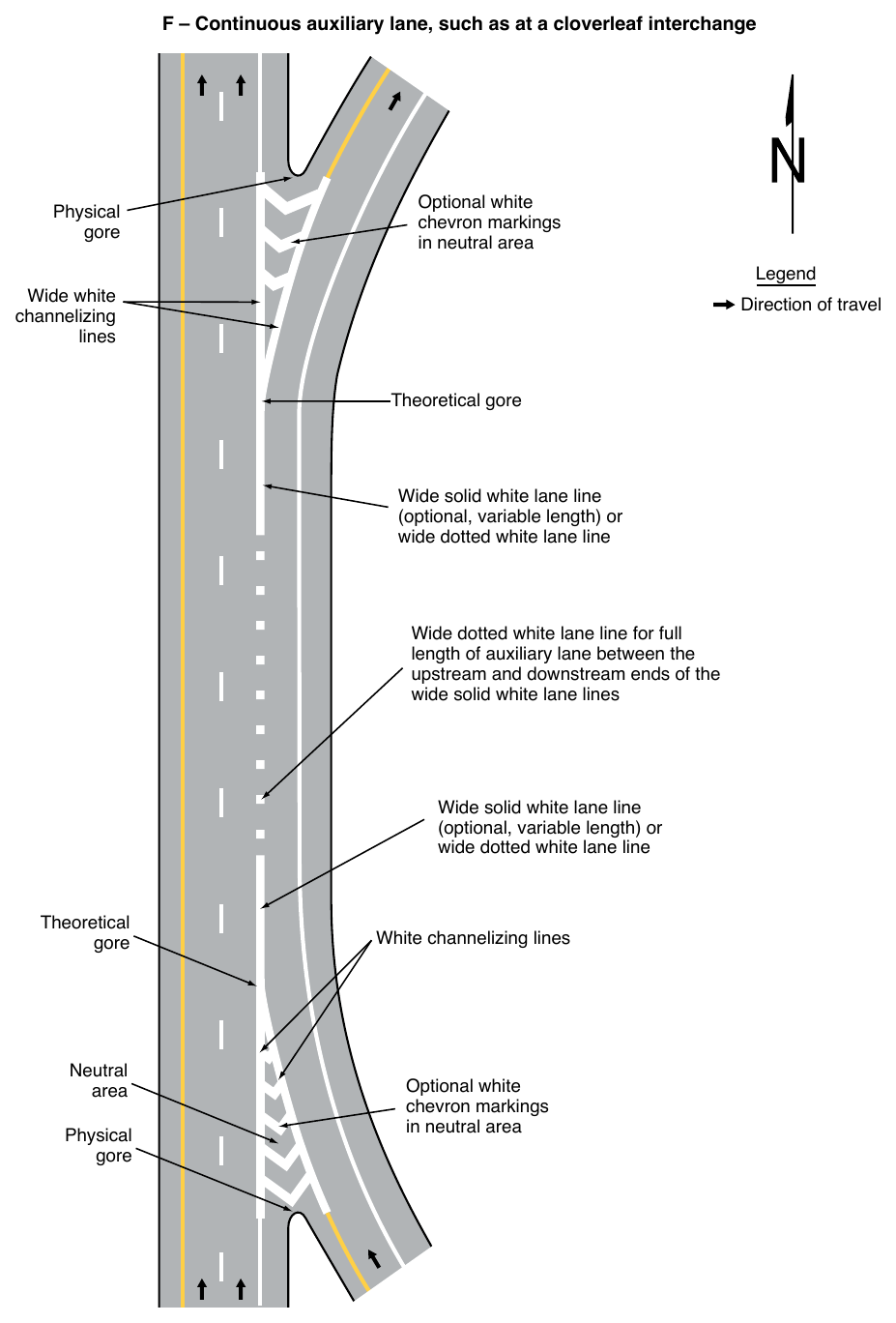
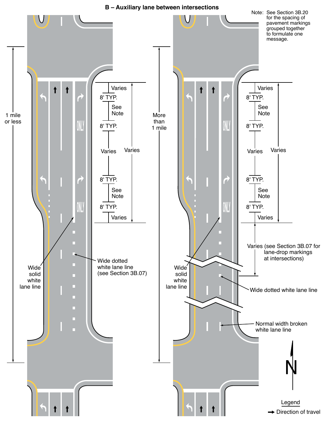
06. (Sheet 2 of 2) B – Auxiliary lane between intersections Varies Varies 1 mile or less See Note More than 1 mile Varies Varies Varies See Note See Note Varies Wide dotted white lane line (see Section 3B.07) See Note Varies Wide solid white lane line Note: See Section 3B.20 for the spacing of pavement markings grouped together to formulate one message. Varies Varies (see Section 3B.07 for lane-drop markings at intersections) Wide solid white lane line Wide dotted white lane line Normal width broken white lane line Legend Direction of travel For entrance ramps with tapered acceleration lanes, channelizing lines shall be placed along both sides of the neutral area to a point at least one-half of the distance to the theoretical gore (see Drawing C in Figure 3B-10).
07. Channelizing lines shall be placed on both sides of the neutral area for bifurcations created from openroad tolling lanes that bypass a conventional toll plaza.
08. Where neutral areas are formed at access and egress points to and from a managed-lane facility, channelizing lines shall be placed on both sides of the neutral area (see Figures 2G-8, 2G-10, 2G-13, 2G-16, 2G-22, 2G-23, 2G-27, and 2G-28).
Option
09. For entrance ramps with tapered acceleration lanes, the channelizing lines may extend to the theoretical gore as shown in Drawing B in Figure 3B-10.
Standard
10. Other pavement markings in the neutral area shall be white.
Support
11. Pavement markings within the neutral area include chevron markings (see Section 3B.25), retroreflective raised pavement markers (see Section 3B.16), and internally illuminated raised pavement markers (see Section 3B.16).
Option
12. A curved transition may be used where a channelizing line changes direction.
Support
13. Examples of locations where a curved transition can have value include freeway exit and entrance ramps and separated turn lanes.
§3B.09 Edge Line Pavement Markings¶
Standard
01. If used, edge line pavement markings shall delineate the right or left edges of a roadway.
02. Except as provided in Section 3E.04, right edge line pavement markings, if used, shall consist of a normal width solid white line to delineate the right-hand edge of the roadway.
03. If used on the roadways of divided highways or one-way streets, or on any ramp in the direction of travel, left edge line pavement markings shall consist of a normal width solid yellow line to delineate the left-hand edge of a roadway or to indicate driving or passing restrictions left of these markings, except as provided in Section 3E.04.
Support
04. Edge line markings provide visual references to guide road users during adverse weather and visibility conditions.
Option
05. Wide solid edge line markings may be used for greater emphasis.
Support
06. Increasing edge line width from 4 inches to at least 6 inches can be a beneficial countermeasure on all facility types in both urban and rural areas.
Guidance
07. Edge line markings should not be continued through intersections, except for the following situations:
- A. Dotted edge line extensions (see Section 3B.11), or
- B. Through that part of an intersection with no intersection approach (such as the far side of a T-intersection).
Support
08. Section 3B.11 contains information on the use and application of edge lines through intersections, interchanges, and driveways.
Option
09. A curved transition may be used where an edge line changes direction.
Support
10. Examples of locations where a curved transition can have value include freeway exit and entrance ramps and turn lanes.
§3B.10 Warrants for Use of Edge Lines¶
Standard
01. Edge line markings shall be placed on paved streets or highways with the following characteristics:
- A. Freeways,
- B. Expressways, and
- C. Rural arterials with a traveled way of 20 feet or more in width and an ADT of 6,000 vehicles per day or greater.
Guidance
02. Edge line markings should be placed on paved streets or highways with the following characteristics:
- A. Rural arterials and collectors with a traveled way of 20 feet or more in width and an ADT of 3,000 vehicles per day or greater.
- B. On other paved streets and highways where an engineering study indicates a need for edge line markings.
03. Edge line markings should not be placed where an engineering study or engineering judgment indicates that providing them is likely to decrease safety for all road users.
Option
04. Edge line markings may be placed on streets and highways with or without center line markings.
05. Edge line markings may be excluded, based on engineering judgment, for reasons such as if the traveled way edges are delineated by curbs, parking, or other markings.
06. If a bicycle lane is marked on the outside portion of the traveled way, the edge line that would mark the outside edge of the bicycle lane may be omitted.
07. Edge line markings may be used where edge delineation is desirable to minimize unnecessary driving on paved shoulders or on refuge areas that have lesser structural pavement strength than the adjacent roadway.
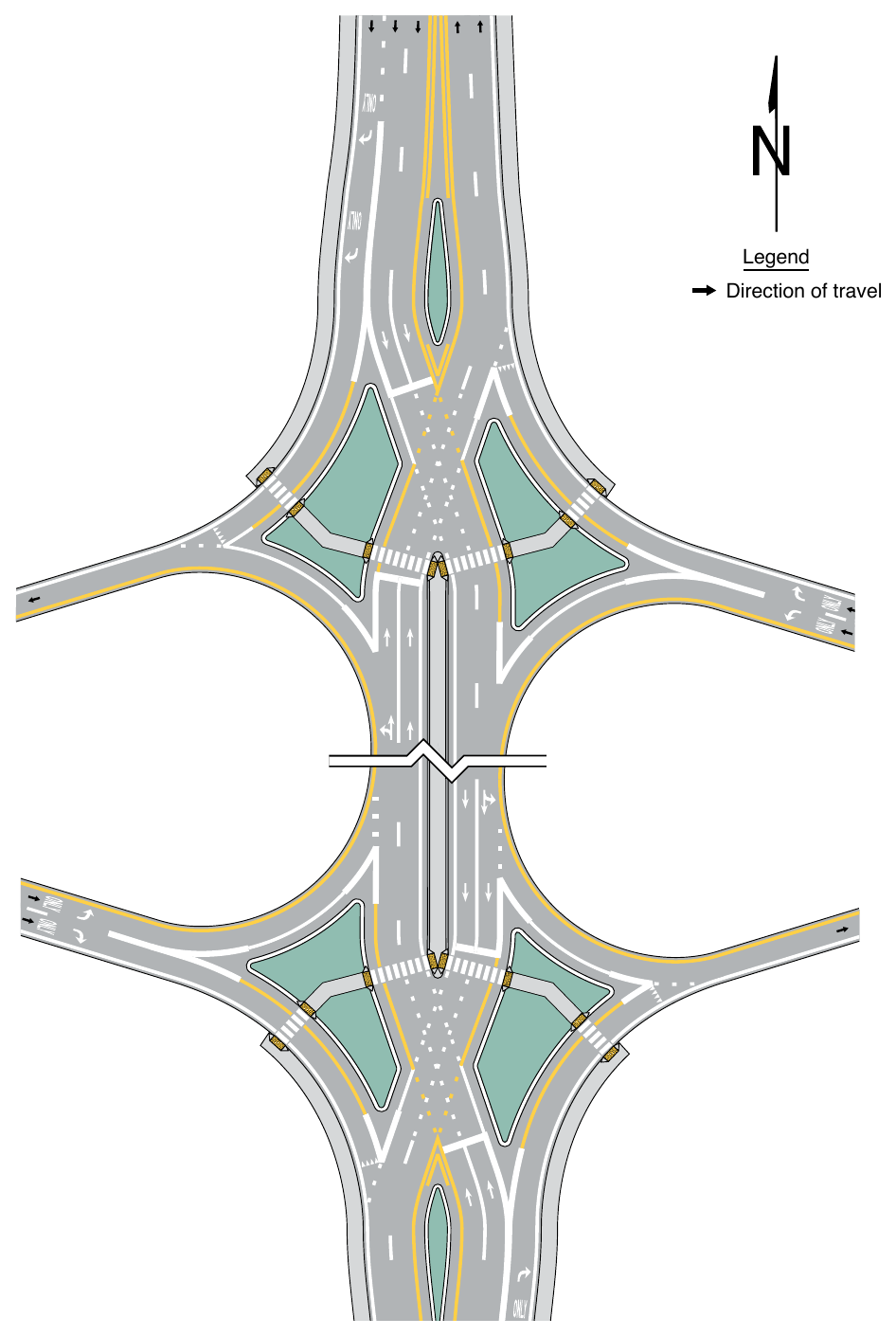
§3B.11 Application of Pavement Markings through Intersections or Interchanges¶
Standard
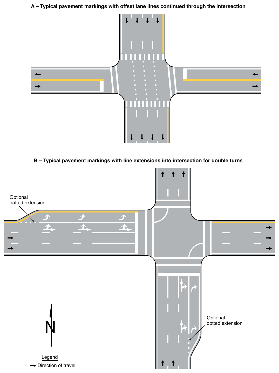
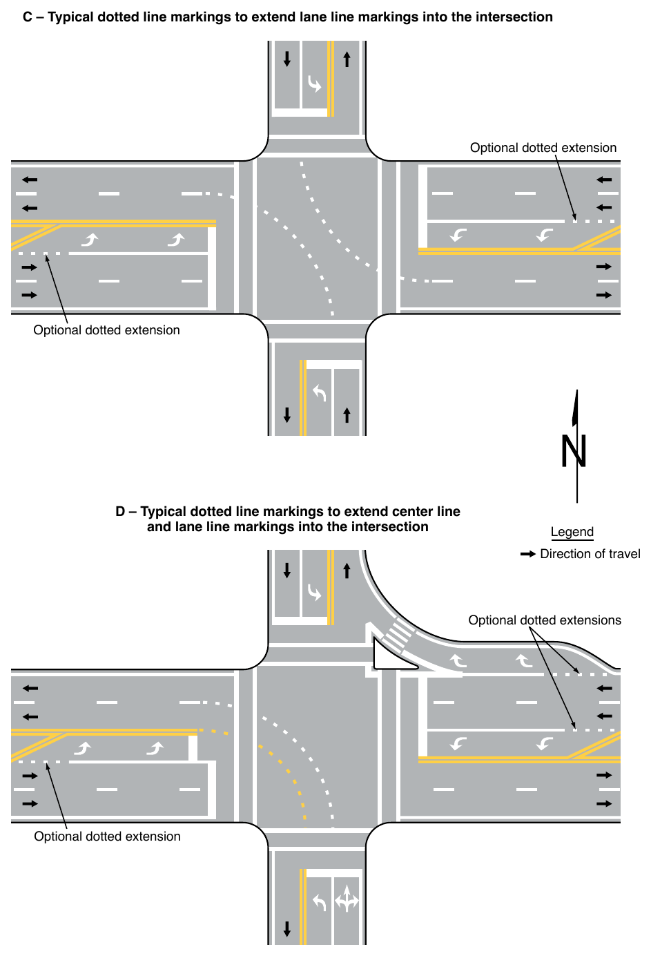
01. Pavement markings extended into or continued through an intersection or interchange area shall be the same color as the line markings they extend (see Figure 3B-13).
Guidance
02. Pavement markings extended into or continued through an intersection or interchange area should be at least the same width as the line markings they extend.
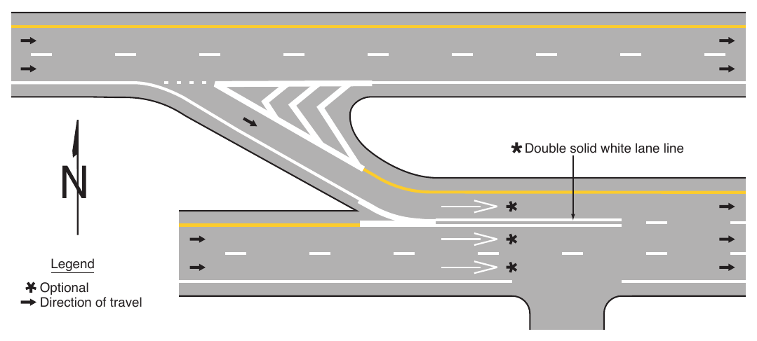
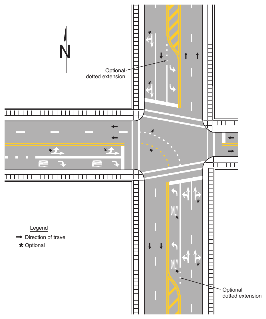
03. Where highway design or reduced visibility conditions make it desirable to provide control or to guide vehicles through an intersection or interchange, such as at offset, skewed, complex, or multi-leg intersections, on curved roadways, where multiple turn lanes are used, or where offset left-turn lanes might cause driver confusion, dotted lane line extension markings consisting of 2-foot line segments and 2-foot to 6-foot gaps should be used to extend longitudinal line markings through an intersection or interchange area.
04. Where greater restriction is preferred, solid lane lines or channelizing lines should be extended into or continued through intersections.
Standard
05. Extensions of center lines through intersections shall be dotted lines.
Guidance
06. Where a double line is extended through an intersection, a single line of equal width to one of the lines of the double line should be used.
Standard
07. Solid lines shall not be used to extend edge lines into or through intersections except through that part of an intersection with no intersecting approach (such as at the far side of a T-intersection).
Guidance
08. Edge line markings should be discontinued across intersecting approaches at intersections or interchanges.
09. Driveways that do not meet the definition of an intersection (see Section 1C.02) should have edge line markings maintained across the intersecting approach of the driveway.
Option
10. Dotted edge line extensions may be placed through intersections.
Support
11. Section 3B.31 contains information about edge lines through diamond interchanges with a transposed alignment crossroad.
12. Section 3D.03 provides information for edge lines through roundabouts.
13. Section 5B.02 contains information on edge line extensions for driving automation system considerations.
14. Section 8C.05 contains information about the extension of edge lines through grade crossing areas.
15. Section 9E.03 contains information for the extensions of bicycle lanes through intersections.
§3B.12 Lane-Reduction Transitions¶
Support
01. A lane-reduction is where the number of through lanes is reduced at a location that is not at an interchange or intersection because of narrowing of the roadway or because of a section of on-street parking in what would otherwise be a through lane.
02. Section 3B.07 contains information on pavement markings for lane drops and splits.
03. Section 2C.47 contains information for warning signing used for lane reductions.
Standard
04. Lane-reduction transitions (see Figure 3B-14) shall include the following elements:
- A. A no-passing zone (see Section 3B.03) to prohibit passing in the direction of the convergence and through the transition area except where not applicable such as one-way streets, expressways, and freeways; and
- B. An edge line (see Section 3B.09) in the direction of the convergence and through the transition area, except as provided in Paragraph 6 of this Section.
Guidance
05. Except as provided in Paragraph 6 of this Section, the edge line marking should be installed from the location of the Lane Ends warning sign to beyond the beginning of the narrower roadway.
Option
06. On roadways with operating speeds less than 25 mph where curbs clearly define the roadway edge in the lanereduction transition, or where a through lane becomes a parking lane, the edge line may be omitted as determined by engineering judgment.
Guidance
07. Lane-reduction transitions should include the following elements:
- A. Delineators installed adjacent to the lane or lanes reduced for the full length of the transition and should be so placed and spaced (see Section 3G.04) to show the reduction except as provided in Paragraph 13 of this Section and except as provided in Paragraph 2 of Section 3G.03 for freeways and expressways,
- B. Lane-reduction arrow markings (see Drawing I in Figure 3B-21) on the roadway with a speed limit of 45 mph or more, and
- C. A termination of the broken white lane line at a point that is ¼ of the advance placement distance (see Section 2C.04) between the Lane Ends sign (see Section 2C.47) and the point where the transition taper begins.
08. For roadways having a speed limit of 45 mph or greater, the transition taper length for a lane-reduction transition should be computed by the formula L = WS, where L equals the taper length in feet, W equals the width of the offset distance in feet, and S equals the 85th-percentile speed or the speed limit in mph, whichever is higher. For roadways where the speed limit is less than 45 mph, the formula L = WS²/60 should be used to compute the taper length.
09. The minimum lane reduction transition taper length should be 100 feet in urban areas and 200 feet in rural areas.
10. Where observed speeds exceed speed limits, longer tapers should be used.
Option
11. The minimum taper length may be less than 100 feet on roadways where the operating speed is less than 25 mph.
12. On new construction, where no speed limit has been established, the design speed may be used in the transition taper length formula.
13. On low-speed urban roadways where curbs clearly define the roadway edge in the lane-reduction transition, or where a through lane becomes a parking lane, delineators may be omitted as determined by engineering judgment.
14. Where a lane-reduction transition occurs on a roadway with a speed limit of less than 45 mph, lane-reduction arrow markings may be used.
15. Lane-reduction arrow markings may be used in long acceleration lanes based on engineering judgment.
16. A dotted white line may be used between the point where the broken white lane line is terminated to the point where the transition taper begins.
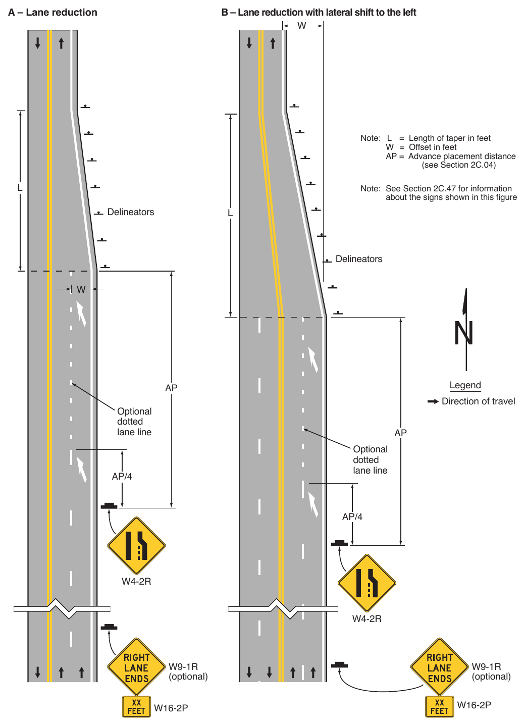
Signs shown: W4-2R, W9-1R, W16-2P
§3B.13 Approach Markings for Obstructions¶
Standard
01. Pavement markings shall be used to guide traffic away from fixed obstructions within a paved roadway. Approach markings for bridge supports, refuge islands, median islands, toll plaza islands, and raised channelization islands shall consist of a tapered line or lines extending from the center line or the lane line to a point 1 to 2 feet to the right-hand side, or to both sides, of the approach end of the obstruction (see Figure 3B-15).
Guidance
02. For roadways having a speed limit of 45 mph or greater, the taper length of the tapered line markings should be computed by the formula L = WS, where L equals the taper length in feet, W equals the width of the offset distance in feet, and S equals the 85th-percentile speed or the speed limit, whichever is higher. For roadways where the speed limit is less than 45 mph, the formula L = WS²/60 should be used to compute the taper length.
03. The minimum taper length should be 100 feet in urban areas and 200 feet in rural areas.
Option
04. The minimum taper length may be less than 100 feet on roadways where the operating speed is less than 25 mph.
Standard
05. If traffic is required to pass only to the right of the obstruction, the markings shall consist of a two-direction no-passing zone marking at least twice the length of the diagonal portion as determined by the appropriate taper formula (see Drawing A in Figure 3B-15).
Option
06. If traffic is required to pass only to the right of the obstruction, yellow diagonal markings (see Section 3B.25) may be placed in the flush median islands (see Section 3J.03) between the no-passing zone markings as shown in Drawings A and B in Figure 3B-15.
Standard
07. If traffic can pass either to the right or left of the obstruction, the markings shall consist of two channelizing lines diverging from the lane line, one to each side of the obstruction. In advance of the point of divergence, a wide solid white line or normal width double solid white line shall be extended in place of the broken lane line for a distance equal to the length of the diverging lines (see Drawing C in Figure 3B-15).
Option
08. If traffic can pass either to the right or left of the obstruction, additional white chevron markings (see Section 3B.25) may be placed in the flush neutral area between the channelizing lines as shown in Drawing C in Figure 3B-15. Other markings, such as white delineators, white channelizing devices, white raised pavement markers, and white crosswalk markings may also be placed in the flush neutral area.
§3B.14 Raised Pavement Markers – General¶
Standard
01. The color of raised pavement markers under both daylight and nighttime conditions shall conform to the color of the marking for which they serve as a positioning guide, or for which they supplement or substitute.
Option
02. The side of a raised pavement marker that is visible to traffic proceeding in the wrong direction may be red (see Section 3A.03).
03. Retroreflective or internally illuminated raised pavement markers may be used in the roadway immediately adjacent to curbed approach ends of raised medians and curbs of islands, or on top of such curbs (see Section 3J.06).
Standard
04. When used, internally illuminated raised pavement markers shall be steadily illuminated and shall not be flashed.
Support
05. Flashing raised pavement markers are considered to be In-Roadway Warning Lights (see Chapter 4U).
Guidance
06. The spacing of raised pavement markers used to supplement or substitute for other types of longitudinal markings should correspond with the pattern of broken lines for which the markers supplement or substitute.
Standard
07. The value of N cited in Sections 3B.15 through 3B.17 for the spacing of raised pavement markers shall equal the length of one line segment plus one gap of the broken lines used on the highway.
Option
08. For additional emphasis, retroreflective raised pavement markers may be spaced closer than described in Sections 3B.15 through 3B.17, as determined by engineering judgment or engineering study.
Support
09. Section 9A.03 contains information for the application of raised pavement markers to bicycle facilities.
§3B.15 Raised Pavement Markers as Vehicle Positioning Guides with Other Longitudinal Markings¶
Option
01. Retroreflective or internally illuminated raised pavement markers may be used as positioning guides with longitudinal line markings without necessarily conveying information to the road user about passing or lane-use restrictions. In such applications, markers may be positioned in line with or immediately adjacent to a single line marking, or positioned between the two lines of a double center line or double lane line marking.
Guidance
02. Except as otherwise provided in Paragraphs 3 and 4 of this Section, the spacing for such applications should be 2N (see Section 3B.14).
Option
03. Where it is desired to alert the road user to changes in the travel path, such as on sharp curves or on transitions that reduce the number of lanes or that shift traffic laterally, the spacing may be reduced to N or less.
04. On freeways and expressways, the spacing may be increased to 3N for relatively straight and level roadway segments where engineering judgment indicates that such spacing will provide adequate delineation under wet night conditions.
§3B.16 Raised Pavement Markers Supplementing Other Markings¶
Guidance
01. The use of retroreflective or internally illuminated raised pavement markers for supplementing longitudinal line markings should comply with the following:
- A. Lateral Positioning
- 1. When supplementing double line markings, pairs of raised pavement markers placed laterally in line with or immediately outside of the two lines should be used.
- 2. When supplementing wide line markings, pairs of raised pavement markers placed laterally adjacent to each other should be used.
- B. Longitudinal Spacing
- 1. When supplementing solid line markings, raised pavement markers at a spacing no greater than N (see Section 3B.14) should be used, except that when supplementing channelizing lines or edge line markings, a spacing of no greater than N/2 should be used.
- 2. When supplementing broken line markings, a spacing no greater than 3N should be used. However, when supplementing broken line markings identifying reversible lanes, a spacing of no greater than N should be used.
- 3. When supplementing dotted lane line markings, a spacing appropriate for the application should be used.
- 4. When supplementing longitudinal line extension markings through at-grade intersections, one raised pavement marker for each short line segment should be used.
- 5. When supplementing line extensions through freeway interchanges, a spacing of no greater than N should be used.
02. Raised pavement markers should not supplement right-hand edge lines unless an engineering study or engineering judgment indicates the benefits of enhanced delineation of a curve or other location would outweigh possible impacts on bicyclists using the shoulder, and the spacing of raised pavement markers on the right-hand edge does not simulate a broken line during wet night conditions.
Option
03. Raised pavement markers also may be used to supplement other markings such as channelizing islands, gore areas, approaches to obstructions, or wrong-way arrows.
04. To improve the visibility of horizontal curves, center lines may be supplemented with retroreflective or internally illuminated raised pavement markers for the entire curved section as well as for a distance in advance of the curve that approximates 5 seconds of travel time.
§3B.17 Raised Pavement Markers Substituting for Pavement Markings¶
Option
01. Retroreflective or internally illuminated raised pavement markers, or non-retroreflective raised pavement markers supplemented by retroreflective or internally illuminated markers, may be substituted for markings of other types.
Guidance
02. If used, the pattern of the raised pavement markers should simulate the pattern of the markings for which they substitute.
Standard
03. Non-retroreflective raised pavement markers shall not be used alone, without supplemental retroreflective or internally illuminated markers, as a substitute for other types of pavement markings.
Support
04. Section 6J.03 contains information for flexible temporary pavement markers used during surface treatment paving operations.
Standard
05. If raised pavement markers are used to substitute for broken line markings, a group of three to five markers equally spaced at a distance no greater than N/8 (see Section 3B.14) shall be used. If N is other than 40 feet, the markers shall be equally spaced over the line segment length (at ½ points for three markers, at ¹⁄³ points for four markers, and at ¼ points for five markers). At least one retroreflective or internally illuminated marker per group shall be used or a retroreflective or internally illuminated marker shall be installed midway in each gap between successive groups of non-retroreflective markers.
06. When raised pavement markers substitute for solid line markings, the markers shall be equally spaced at no greater than N/4, with retroreflective or internally illuminated units at a spacing no greater than N/2.
Guidance
07. Raised pavement markers should not substitute for right-hand edge line markings unless an engineering study or engineering judgment indicates the benefits of enhanced delineation of a curve or other location would outweigh possible impacts on bicyclists using the shoulder, and the spacing of raised pavement markers on the right-hand edge line does not simulate a broken line during wet night conditions.
Standard
08. When raised pavement markers substitute for dotted lines, they shall be spaced at no greater than N/4, with not less than one raised pavement marker per dotted line segment. At least one raised marker every N shall be retroreflective or internally illuminated.
Option
09. When substituting for wide lines, raised pavement markers may be placed laterally adjacent to each other to simulate the width of the line.
Support
10. Section 5B.02 contains information on raised pavement marker considerations for driving automation systems.
§3B.18 Curb Markings for Parking Regulations¶
Guidance
01. Except as provided in Paragraph 3 of this Section, since yellow and white curb markings are frequently used for curb delineation and visibility, parking regulations should be established through the installation of standard signs (see Sections 2B.53 and 2B.54), especially in areas where curb markings are frequently obscured by snow and ice accumulation.
02. Except as provided in Paragraph 3 of this Section, when curb markings are used without signs to convey parking regulations, a legible word marking regarding the regulation (such as “No Parking” or “No Standing”) should be placed on the curb.
Option
03. Curb markings without word markings or signs may be used to convey a general prohibition by statute of parking within a specified distance of a STOP sign, YIELD sign, driveway, fire hydrant, or crosswalk.
04. Local highway agencies may prescribe special colors for curb markings to supplement standard signs for parking regulation.
§3B.19 Stop and Yield Lines¶
Option
01. Stop lines may be used to indicate the point behind which vehicles are required to stop in compliance with a STOP (R1-1) sign, a Stop Here for Pedestrians (R1-5b) sign, a Stop Here for School Crossing (R1-5c) sign, a Stop Here for Trail Crossing (R-5e) sign, or some other traffic control device that requires vehicles to stop, except YIELD signs that are not associated with passive grade crossings.
Standard
02. Stop lines shall consist of solid white lines extending across approach lanes to indicate the point at which the stop is intended or required to be made.
03. Except as provided in Section 8C.03, stop lines shall not be used at locations where drivers are required to yield in compliance with a YIELD (R1-2) sign, a Yield Here to Pedestrians (R1-5) sign, a Yield Here to School Crossings (R1-5a) sign, a Yield Here to Trail Crossings (R1-5d) sign, or at locations on uncontrolled approaches where drivers or bicyclists are required by State law to yield to pedestrians.
Guidance
04. Stop lines should be used to indicate the point behind which vehicles are required to stop in compliance with a traffic control signal (see Section 4D.08).
05. Stop lines should be 12 to 24 inches wide.
Option
06. Stop lines may be omitted at ramp control signals.
Support
07. Section 4J.02 contains information regarding the use and application of stop lines in conjunction with a pedestrian hybrid beacon.
Standard
08. If used, a yield line pavement marking shall not be installed without a Yield (R1-2) sign, a Yield Here to Pedestrians (R1-5) sign, a Yield Here to School Crossings (R1-5a) sign, a Yield Here to Trail Crossings (R1-5d) sign, or some other traffic control device that requires vehicles to yield (see Figure 3B-16).
09. Yield lines shall not be used at locations where drivers are required to stop in compliance with a STOP (R1-1) sign, a Stop Here for Pedestrians (R1-5b) sign, a Stop Here for School Crossing (R1-5c) sign, a Stop Here for Trail Crossing (R1-5e) sign, a traffic control signal, or some other traffic control device.
10. Yield lines shall consist of a row of solid white isosceles triangles pointing toward approaching vehicles extending across approach lanes to indicate the point at which the yield is intended or required to be made.
Option
11. If a yield line marking is used on a bicycle facility, a Bicycles Yield to Pedestrians (R9-6) sign (see Section 9B-12) may be used.
Guidance
12. The individual triangles comprising the yield line should have a base of 12 to 24 inches wide and a height equal to 1.5 times the base. The space between the triangles should be 3 to 12 inches.
13. If used, stop and yield lines should be placed a minimum of 4 feet in advance of the nearest crosswalk line at controlled intersections, except for yield lines at roundabouts as provided for in Section 3D.04 and at midblock crosswalks. In the absence of a marked crosswalk, the stop line or yield line should be placed at the desired stopping or yielding point, but should not be placed more than 30 feet or less than 4 feet from the nearest edge of the intersecting traveled way.
Standard
14. If yield (stop) lines are used at a crosswalk that crosses an uncontrolled multi-lane approach, Yield Here to (Stop Here for) Pedestrians (R1-5 series) signs (see Section 2B.19) shall be used.
Guidance
15. If yield (stop) lines are used at a crosswalk that crosses an uncontrolled multi-lane approach, the yield (stop) line should be placed 20 to 50 feet in advance of the nearest crosswalk line (see Drawing B in Figure 3B-16).
16. If yield or stop lines are used in advance of a crosswalk that crosses an uncontrolled multi-lane approach, parking should be prohibited in the area between the yield or stop line and the crosswalk.
Support
17. Section 9B.12 contains information for providing signing applicable to bicyclists also subject to a yielding requirement at a crosswalk that crosses an uncontrolled approach.
Guidance
18. Yield (stop) lines and Yield Here to (Stop Here for) Pedestrians signs should not be used in advance of crosswalks that cross an approach to or departure from a circular intersection.
Support
19. Section 8C.03 contains information regarding the use of stop lines and yield lines at grade crossings.
Option
20. Stop and yield lines may be staggered longitudinally on a lane-by-lane basis (see Drawing D in Figure 3B-13).
Support
21. Staggered stop lines and staggered yield lines can improve the driver’s view of pedestrians, provide better sight distance for turning vehicles, and increase the turning radius for left-turning vehicles.
§3B.20 Word, Symbol, and Arrow Pavement Markings – General¶
Support
01. Word, symbol, and arrow markings on the pavement are used for the purpose of regulating, warning, or guiding traffic. These pavement markings can be helpful to road users in some locations by supplementing signs and providing additional emphasis for important regulatory, warning, or guidance messages, because the markings do not require diversion of the road user’s attention from the roadway surface. Symbol messages are preferable to word messages. Examples of standard word and arrow pavement markings are shown in Figures 3B-17 and 3B-21, respectively.
Option
02. Word, symbol, and arrow pavement markings may be used as determined by engineering judgment to supplement signs and/or to provide additional emphasis for regulatory, warning, or guidance messages provided by other devices.
Support
03. Section 8C.04 contains information for arrow pavement markings in the vicinity of grade crossings.
Standard
04. Word, symbol, and arrow markings shall be white, except as otherwise provided in Sections 3A.03 and 3B.22.
05. Pavement marking letters, numerals, symbols, and arrows shall be installed in accordance with the design details in the Pavement Markings chapter of the “Standard Highway Signs” publication (see Section 1A.05).
Guidance
06. Word, symbol, and/or arrow markings that are grouped together to formulate one interrelated message should not exceed three lines of information.
07. Except for the two opposing white arrows of a two-way left-turn lane marking (see Figure 3B-7) and the pavement word marking messages described in Items B and D of Paragraph 2 of Section 3B.26, the longitudinal space between word, symbol, and/or arrow markings that are used together to formulate one interrelated message should be at least four times the height of the characters for low-speed roads, but not more than ten times the height of the characters under any conditions.
08. Except for the SCHOOL word marking (see Section 7C.02), pavement word, symbol, and arrow markings should be no more than one lane in width.
09. Pavement word, symbol, and arrow markings should be proportionally scaled to fit within the width of the facility upon which they are applied.
Option
10. On narrow, low-speed shared-use paths, the pavement words, symbols, and arrows may be smaller than suggested, but to the relative scale.
11. On roadways where the operating speed is less than 25 mph, word, symbol, and arrow markings may be proportionally reduced by 25 percent.
§3B.21 Word Pavement Markings¶
Guidance
01. Letters and numerals should be 6 feet or more in height, except as provided in Section 9E.01 for the BIKE LANE word pavement marking and in Section 9E.15 for a bicycle detector symbol and WAIT HERE FOR GREEN word pavement marking.
02. If a pavement marking word message consists of more than one line of information, it should read in the direction of travel. The first word of the message should be nearest to the road user.
Standard
03. The word STOP shall not be placed on the pavement in advance of a stop line, unless every vehicle is required to stop at all times.
Guidance
04. Where through lanes approaching an intersection become mandatory turn lanes, ONLY word pavement markings (see Figure 3B-17) should be used in addition to signs (see Sections 2B.27 and 2B.28) and the required lane-use arrow markings (see Section 3B.23).
Option
05. The ONLY word marking may be used to supplement the lane-use arrow markings in lanes that are designated for the exclusive use of a single movement such as turn bays.
06. The ONLY word marking may be used to supplement a preferential lane word or symbol marking (see Section 3E.03).
07. On roadways where the operating speed is less than 25 mph, word markings may be proportionally reduced by 25 percent.
Standard
08. The ONLY word marking shall not be used in a lane that is shared by more than one movement.
§3B.22 Symbol Pavement Markings¶
Support
01. Section 3E.03 contains information on the diamondshaped symbol for high-occupancy vehicle (HOV) lanes.
02. Chapter 9E contains information on symbol markings that can be used for bicycle lanes.
Option
03. Pavement markings simulating Interstate, U.S., State, and County route signs (see Figure 2D-4) with appropriate route numbers, but elongated for proper proportioning when viewed as a marking, may be used to guide road users to their destinations (see Figure 3B-18).
Guidance
04. If route sign markings are provided to guide road users, those route sign markings should be provided in option lanes if markings are provided in any lanes.
05. If two route sign markings are provided in an option lane, they should be placed in sequence and not divided around an optional lane arrow.
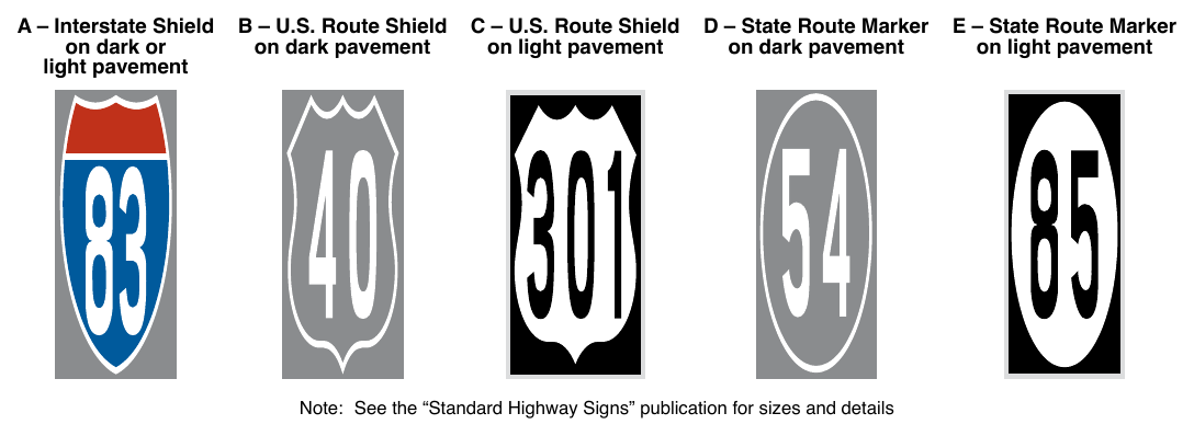
B – U.S. Route Shield on dark pavement C – U.S. Route Shield on light pavement D – State Route Marker on dark pavement E – State Route Marker on light pavement Note: See the “Standard Highway Signs” publication for sizes and details
Support
06. Section 3A.03 provides information on route sign colors.
07. Section 9E.14 contains information on route markers for designated bicycle routes that can be used on shared-use paths.
Guidance
08. The International Symbol of Accessibility parking space marking (see Figure 3B-19) should be placed in each parking space designated for use by persons with disabilities.
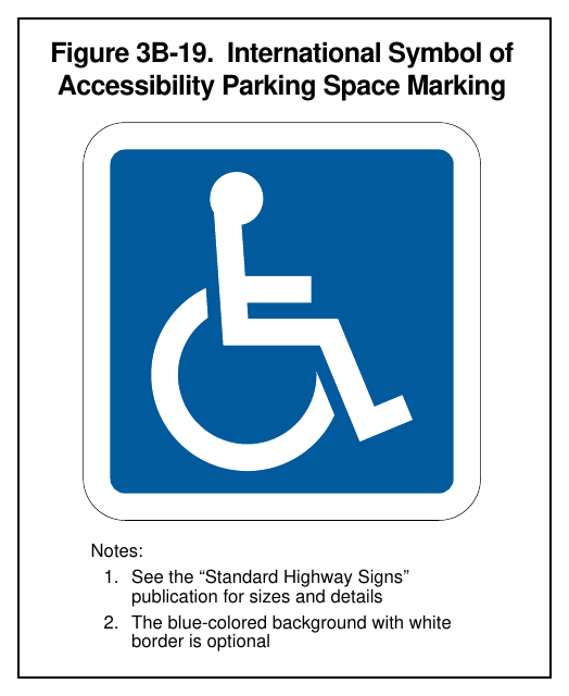
Option
09. A blue background with white border may supplement the wheelchair symbol as shown in Figure 3B-19.
10. A yield-ahead triangle symbol or YIELD AHEAD word pavement marking may be used on approaches to intersections where the approaching traffic will encounter a YIELD sign at the intersection.
Standard
11. The yield-ahead triangle symbol or YIELD AHEAD word pavement marking shall not be used unless a YIELD sign (see Section 2B.05) is in place at the intersection. The yield-ahead triangle symbol marking shall be as shown in Figure 3B-20.
Option
12. A pedestrian symbol pavement marking may be used on portions of facilities that are reserved exclusively for pedestrian use, such as where a shared-use path transitions to become separate facilities for different types of users.
§3B.23 Lane-Use Arrows¶
Support
01. Lane-use arrow markings (see Figure 3B-21) are used to indicate the mandatory or permissible movements in certain lanes (see Figure 3B-22) and in two-way left-turn lanes (see Figure 3B-7).
02. Section 8C.04 contains information about the placement of lane-use arrow markings in the vicinity of grade crossings.
Guidance
03. Lane-use arrow markings should be used in lanes and turn bays designated for the exclusive use of a turning movement, except where engineering judgment determines that physical conditions or other markings (such as a dotted extension of the lane line through the taper into the turn bay) clearly discourage unintentional use of a turn bay by through vehicles. Lane-use arrow markings should also be used in lanes from which movements are allowed that are contrary to the normal rules of the road (see Drawing B in Figure 3B-13).
04. When used in turn lanes, at least two arrows should be used, one at or near the upstream end of the fullwidth turn lane and one an appropriate distance upstream from the stop line or intersection (see Drawing A in Figure 3B-12).
05. Where opposing offset channelized left-turn lanes exist, lane-use arrow markings should be placed near the downstream terminus of the offset left-turn lanes to reduce wrong-way movements (see Figure 2B-20).
Option
06. An additional arrow or arrows may be used in a turn lane. When arrows are used for a short turn lane, the second (downstream) arrow may be omitted based on engineering judgment.
Support
07. An arrow at the downstream end of a turn lane can help to prevent wrong-way movements.
Standard
08. Where through lanes approaching an intersection become mandatory turn lanes, turn lane-use arrow markings (see Drawing A in Figure 3B-12 and Figure 3B-21) shall be used and shall be accompanied by standard signs (see Section 2B.28).
Guidance
09. Where through lanes approaching an intersection become mandatory turn lanes, ONLY word markings (see Figure 3B-17) should be used in addition to signs (see Sections 2B.27 and 2B.28) and the required turn lane-use arrow markings. These signs and markings should be placed well in advance of the turn and should be repeated as necessary to provide the through motorist advance notification to vacate the lane prior to reaching a point where roadway geometrics or a queue of waiting vehicles forces the motorist to make an unintended turn.
Option
10. On freeways or expressways where a through lane becomes a mandatory exit lane, lane-use arrow markings may be used on the approach to the exit in the dropped lane and in an adjacent optional through-or-exit lane if one exists.
§3B.24 Wrong-Way Arrows¶
Guidance
01. Where crossroad channelization or ramp geometrics do not make wrong-way movements difficult, the appropriate lane-use arrow should be placed in each lane of an exit ramp near the crossroad terminal where it will be clearly visible to a potential wrong-way road user (see Figure 2B-15).
Option
02. The wrong-way arrow markings shown in Drawing G in Figure 3B-21 may be placed near the downstream terminus of a ramp as shown in Figure 2B-15 and in Drawing A in Figure 2B-16, or at other locations where laneuse arrows are not appropriate, to indicate the correct direction of traffic flow and to discourage drivers from traveling in the wrong direction.
§3B.25 Chevron and Diagonal Markings¶
Support
01. Chevron or diagonal markings are used to discourage travel on certain paved areas, such as shoulders, neutral areas, and flush median islands.
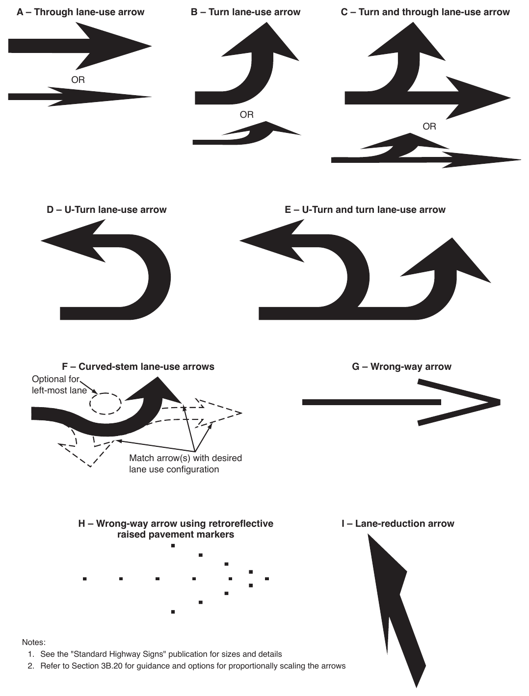
Match arrow(s) with desired lane use configuration H – Wrong-way arrow using retroreflective raised pavement markers I – Lane-reduction arrow Notes:
- 1. See the "Standard Highway Signs" publication for sizes and details
- 2. Refer to Section 3B.20 for guidance and options for proportionally scaling the arrows
Option
02. Chevron and diagonal markings may be used:
- A. On approaches to obstructions in the roadway (see Sheet 2 of Figure 3B-15),
- B. For channelized travel paths on approaches to intersections,
- C. In buffer spaces between preferential lanes and general-purpose lanes (see Drawing A in Figure 3E-2),
- D. In the neutral area gores (see Figures 3B-9 through 3B-11),
- E. In the neutral area of bifurcations created from open-road tolling lanes that bypass a conventional toll plaza,
- F. In the neutral areas at access and egress points to and from a managed-lane facility (see Figures 2G-8, 2G-10, 2G-22, and 2G-23), and
- G. In the neutral areas of islands.
03. Chevron markings may be supplemented with white retroreflective or internally illuminated raised pavement markers (see Section 3B.16) for enhanced nighttime visibility.
Support
04. Section 5B.02 contains information on chevron markings for driving automation system considerations.
Standard
05. Except as provided in Section 3J.03, chevron markings shall be white, with the point of each chevron facing toward approaching traffic, as shown in Figures 3B-9 through 3B-11, and Drawing C in Figure 3B-15.
Option
06. Diagonal markings for opposing directions of traffic may be used:
- A. On approaches to obstructions in the roadway (see Drawings A and B in Figure 3B-15),
- B. In flush median islands between double solid yellow center line markings (see Figure 3B-5), and
- C. In buffer spaces between preferential lanes and general-purpose lanes (see Drawing D in Figure 3E-4).
07. Diagonal markings may be used on paved shoulders or in no-parking zones, or other locations for special emphasis.
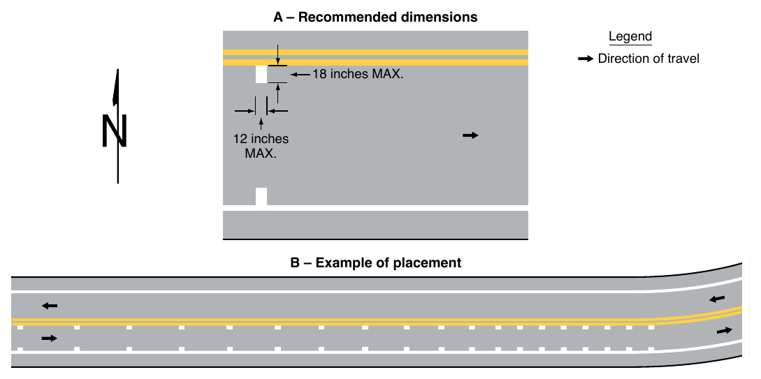
Standard
08. When diagonal markings are used between opposing directions of traffic or on the left shoulder of a one-way or divided roadway, they shall be yellow and slant away from traffic in the adjacent travel lanes, as shown in Figures 3B-2 and 3B-5, and Drawings A and B in Figure 3B-15.
09. When diagonal markings are used on the right shoulder or in no-parking zones (see Figure 3B-23), they shall be white and slant away from traffic in the adjacent travel lane.
Guidance
10. Except as provided in Paragraph 11 of this Section, chevrons and diagonal markings should be at least 12 inches wide for roadways having a speed limit of 45 mph or greater, and at least 8 inches wide for roadways having a speed limit of less than 45 mph. The longitudinal spacing of the chevrons or diagonal lines should be determined by engineering judgment considering factors such as speeds and desired visual impacts. The chevrons and diagonal lines should form an angle of approximately 30 to 45 degrees with the longitudinal lines that they intersect.
Option
11. Diagonal markings used in no-parking zones or on roadways with operating speeds of less than 25 mph may be 4 inches wide (see Figure 3B-23).
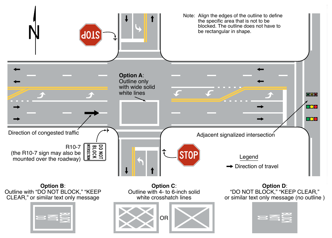
§3B.26 Do Not Block Intersection Markings¶
Option
01. Do Not Block Intersection markings may be used to mark the edges of an intersection area that is in close proximity to a signalized intersection, railroad crossing, or other nearby traffic control that might cause vehicles to stop within the intersection and impede other traffic entering the intersection. If authorized by law, Do Not Block Intersection markings with appropriate signs may also be used at other locations.
Standard
02. If used, Do Not Block Intersection markings (see Figure 3B-24) shall consist of one of the following alternatives:
- A. Wide solid white lines that outline the intersection area that vehicles must not block;
- B. Wide solid white lines that outline the intersection area that vehicles must not block and a white word message such as DO NOT BLOCK or KEEP CLEAR;
- C. Wide solid white lines that outline the intersection area that vehicles must not block and white cross-hatching within the intersection area; or
- D. A white word message, such as DO NOT BLOCK or KEEP CLEAR, within the intersection area that vehicles must not block.
03. DO NOT BLOCK INTERSECTION markings shall be accompanied by one or more DO NOT BLOCK INTERSECTION (DRIVEWAY) (CROSSING) (R10-7) signs (see Section 2B.59), one or more DO NOT STOP ON TRACKS (R8-8) signs (see Section 8B.07), or one or more similar signs.
§3B.27 Parking Space Markings¶
Standard
01. On-street parking space markings shall be white.
Support
02. Examples of on-street parking space markings are shown in Figure 3B-23.
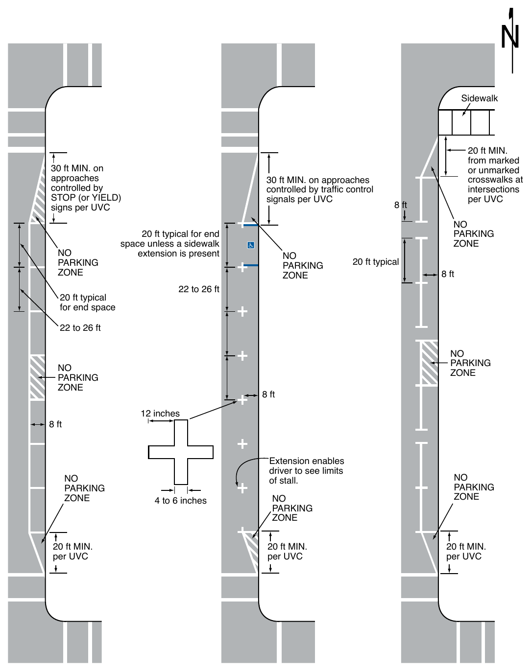
30 ft MIN. on approaches controlled by STOP (or YIELD) signs per UVC 20 ft typical for end space 30 ft MIN. on approaches controlled by traffic control signals per UVC 20 ft typical for end space unless a sidewalk extension is present 22 to 26 ft 20 ft MIN. from marked or unmarked crosswalks at intersections per UVC 8 ft 20 ft typical 8 ft 22 to 26 ft 12 inches 8 ft 20 ft MIN. per UVC 8 ft Extension enables driver to see limits of stall. 4 to 6 inches 20 ft MIN. per UVC 20 ft MIN. per UVC
Signs shown: R10-7
Option
03. Blue lines may supplement white parking space markings of each parking space designated for use only by persons with disabilities (see Figure 3B-23).
Support
04. Additional parking space markings for the purpose of designating spaces for use only by persons with disabilities are discussed in Section 3B.22 and illustrated in Figure 3B-19.
§3B.28 Speed Reduction Markings¶
Support
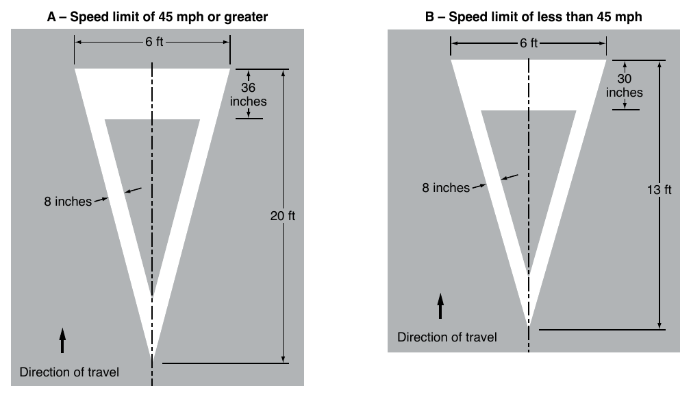
01. Speed reduction markings (see Figure 3B-25) are transverse markings that are placed on the roadway within a lane (along both edges of the lane) in a pattern of progressively reduced spacing to give drivers the impression that their speed is increasing.
02. Speed reduction markings have been shown to enhance safety around curves and locations with a history of run-off-the-road crashes when applied in combination with horizontal alignment warning signs (see Section 2C.05).
Option
03. Speed reduction markings may be placed in advance of an unexpectedly severe horizontal or vertical curve or other roadway feature where drivers need to decelerate prior to reaching the feature and where the desired reduction in speeds has not been achieved by the installation of warning signs and/or other traffic control devices.
Guidance
04. If used, speed reduction markings should be reserved for unexpected curves or other usages based on engineering judgment. Speed reduction markings should not be used on long tangent sections of roadway or in areas frequented mainly by local or familiar drivers, such as school zones. If used, speed reduction markings should supplement the appropriate warning signs and other traffic control devices and should not substitute for these devices.
Standard
05. Speed reduction markings shall be a series of white transverse lines on both sides of the lane that are perpendicular to the center line, edge line, or lane line.
Guidance
06. The longitudinal spacing between the markings should be progressively reduced from the upstream to the downstream end of the marked portion of the lane.
07. Speed reduction markings should not be greater than 12 inches in width, and should not extend more than 18 inches into the lane.
Standard
08. Speed reduction markings shall be used only in lanes that have a longitudinal line (center line, edge line, or lane line) on both sides of the lane.
§3B.29 Speed Hump and Speed Table Markings¶
Standard
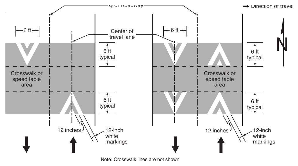
01. If speed hump markings are used, they shall be a series of white markings placed on a speed hump to identify its location. If markings are used for a speed hump that does not also function as a crosswalk or speed table, the markings shall comply with Option A, B, or C shown in Figure 3B-26. If markings are used for a speed hump that also functions as a crosswalk or speed table, the markings shall comply with Option A or B shown in Figure 3B-27.
Option
02. Where used, center line markings, lane line markings, and edge lines may be discontinued on the profile of the speed hump.
Standard
03. Where a speed hump or a speed table specifically incorporates a crossing movement for pedestrians, bicyclists, or equestrians, and functions as a raised crosswalk, crosswalk markings (see Chapter 3C) shall be provided.
§3B.30 Advance Speed Hump and Speed Table Markings¶
Option
01. Advance speed hump markings (see Figure 3B-28) may be used in advance of speed humps or other engineered vertical roadway deflections such as dips where added visibility is desired or where such deflection is not expected.
02. Advance word pavement markings such as BUMP or HUMP (see Section 3B.20) may be used on the approach to a speed hump either alone or in conjunction with advance speed hump markings. Appropriate advance warning signs may be used in compliance with Section 2C.27.
Standard
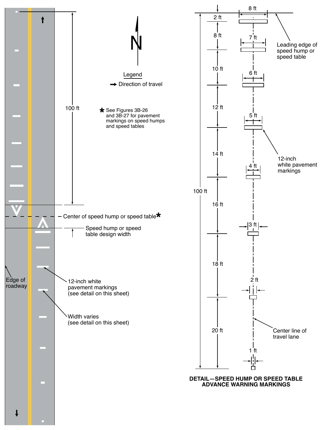
03. If advance speed hump or speed table markings are used, they shall be a series of eight white 12-inch transverse lines that become longer and are spaced closer together as the vehicle approaches the speed hump or other deflection. If advance markings are used, they shall comply with the detailed design shown in Figure 3B-28.
Guidance
04. If used, advance speed hump markings should be installed in each approach lane.
Note: Crosswalk lines are not shown
§3B.31 Markings for a Diamond Interchange with a Transposed Alignment Crossroad¶
Support
01. Markings used in a diamond interchange with a transposed alignment crossroad can be advantageous for minimizing wrong-way movements. The potential for wrong-way movements is greatest at the crossover intersections where the alignment becomes transposed.
Standard
02. On the transposed alignment, each direction shall be considered a one-way roadway whereas the edge line convention shall be in accordance with Section 3B.09. Both yellow and white edge lines shall be used.
03. A lane-use arrow (see Section 3B.23) shall be used in each approach lane at the crossover intersection.
Support
04. Section 3C.11 contains information on crosswalks and pedestrian movements for diamond interchanges with a transposed alignment crossroad.
Standard
05. Flush median islands (see Section 3J.03) shall not be used to divide the inverted flow of traffic.
Guidance
06. Edge line and lane line extensions (see Section 3B.11) should be provided through the crossing points.
Support
07. Figure 3B-29 illustrates an example of pavement markings for a diamond interchange with a transposed alignment crossroad.
(see detail on this sheet) Width varies (see detail on this sheet) 20 ft Center line of travel lane 1 ft DETAIL—SPEED HUMP OR SPEED TABLE